You are here: Home > Network List > NE - New England Seismic Network Stations List
> Station HNH Hanover, NH, USA > Earthquake Result Viewer
HNH Hanover, NH, USA - Earthquake Result Viewer
| Earthquake location: |
Near Coast Of Oaxaca, Mexico |
| Earthquake latitude/longitude: |
15.9/-95.9 |
| Earthquake time(UTC): |
2020/06/23 (175) 15:29:04 GMT |
| Earthquake Depth: |
20 km |
| Earthquake Magnitude: |
7.4 mww |
| Earthquake Catalog/Contributor: |
NEIC PDE/us |
|
| Network: |
NE New England Seismic Network |
| Station: |
HNH Hanover, NH, USA |
| Lat/Lon: |
43.71 N/72.29 W |
| Elevation: |
180 m |
|
| Distance: |
34.2 deg |
| Az: |
31.157 deg |
| Baz: |
223.342 deg |
| Ray Param: |
0.07783214 |
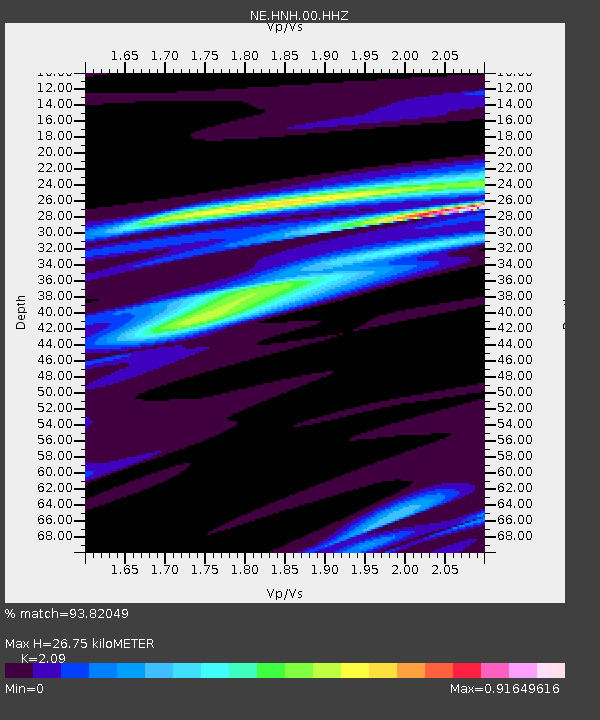
| Estimated Moho Depth: |
26.75 km |
| Estimated Crust Vp/Vs: |
2.09 |
| Assumed Crust Vp: |
6.419 km/s |
| Estimated Crust Vs: |
3.071 km/s |
| Estimated Crust Poisson's Ratio: |
0.35 |
|
| Radial Match: |
93.82049 % |
| Radial Bump: |
278 |
| Transverse Match: |
89.64361 % |
| Transverse Bump: |
243 |
| SOD ConfigId: |
21709731 |
| Insert Time: |
2020-07-07 15:45:03.515 +0000 |
| GWidth: |
2.5 |
| Max Bumps: |
400 |
| Tol: |
0.001 |
|

Signal To Noise
| Channel | StoN | STA | LTA |
| NE:HNH:00:HHZ:20200623T15:35:17.984001Z | 126.58721 | 2.5265354E-5 | 1.995885E-7 |
| NE:HNH:00:HH1:20200623T15:35:17.984001Z | 59.228542 | 1.53715E-5 | 2.5952858E-7 |
| NE:HNH:00:HH2:20200623T15:35:17.984001Z | 55.624702 | 6.554437E-6 | 1.178332E-7 |
| Arrivals |
| Ps | 4.8 SECOND |
| PpPs | 12 SECOND |
| PsPs/PpSs | 17 SECOND |


