You are here: Home > Network List > NN - Western Great Basin/Eastern Sierra Nevada Stations List
> Station WDEM Washoe County DEM, Nevada > Earthquake Result Viewer
WDEM Washoe County DEM, Nevada - Earthquake Result Viewer
| Earthquake location: |
Near Coast Of Oaxaca, Mexico |
| Earthquake latitude/longitude: |
15.9/-95.9 |
| Earthquake time(UTC): |
2020/06/23 (175) 15:29:04 GMT |
| Earthquake Depth: |
20 km |
| Earthquake Magnitude: |
7.4 mww |
| Earthquake Catalog/Contributor: |
NEIC PDE/us |
|
| Network: |
NN Western Great Basin/Eastern Sierra Nevada |
| Station: |
WDEM Washoe County DEM, Nevada |
| Lat/Lon: |
39.58 N/119.81 W |
| Elevation: |
1572 m |
|
| Distance: |
31.5 deg |
| Az: |
323.184 deg |
| Baz: |
131.752 deg |
| Ray Param: |
0.07904941 |
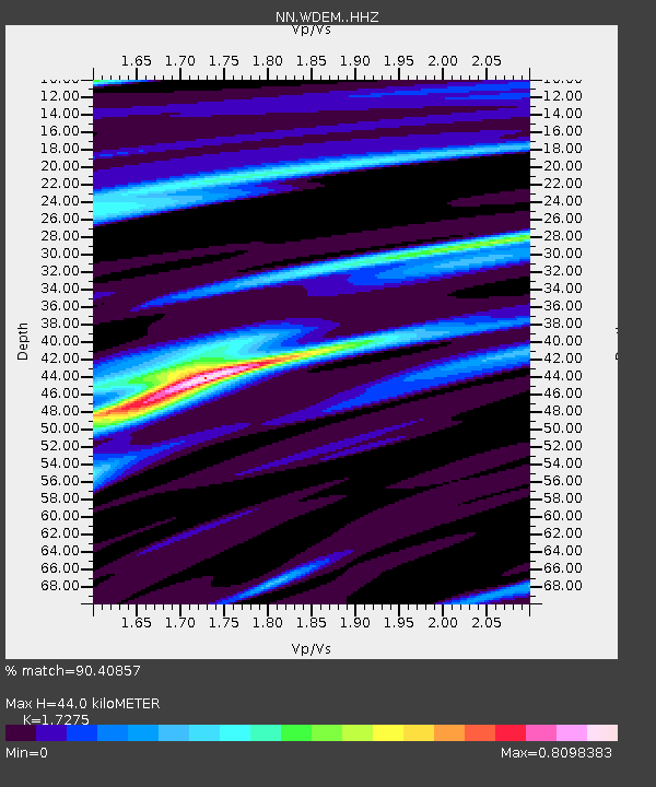
| Estimated Moho Depth: |
44.0 km |
| Estimated Crust Vp/Vs: |
1.73 |
| Assumed Crust Vp: |
6.279 km/s |
| Estimated Crust Vs: |
3.634 km/s |
| Estimated Crust Poisson's Ratio: |
0.25 |
|
| Radial Match: |
90.40857 % |
| Radial Bump: |
400 |
| Transverse Match: |
84.69647 % |
| Transverse Bump: |
400 |
| SOD ConfigId: |
21709731 |
| Insert Time: |
2020-07-07 15:45:26.300 +0000 |
| GWidth: |
2.5 |
| Max Bumps: |
400 |
| Tol: |
0.001 |
|

Signal To Noise
| Channel | StoN | STA | LTA |
| NN:WDEM: :HHZ:20200623T15:34:53.977989Z | 37.98105 | 3.0852136E-6 | 8.123035E-8 |
| NN:WDEM: :HHN:20200623T15:34:53.977989Z | 10.091011 | 1.0684838E-6 | 1.0588471E-7 |
| NN:WDEM: :HHE:20200623T15:34:53.977989Z | 10.034003 | 1.2418357E-6 | 1.2376273E-7 |
| Arrivals |
| Ps | 5.5 SECOND |
| PpPs | 18 SECOND |
| PsPs/PpSs | 23 SECOND |


