You are here: Home > Network List > US - United States National Seismic Network Stations List
> Station ELK Elko, Nevada, USA > Earthquake Result Viewer
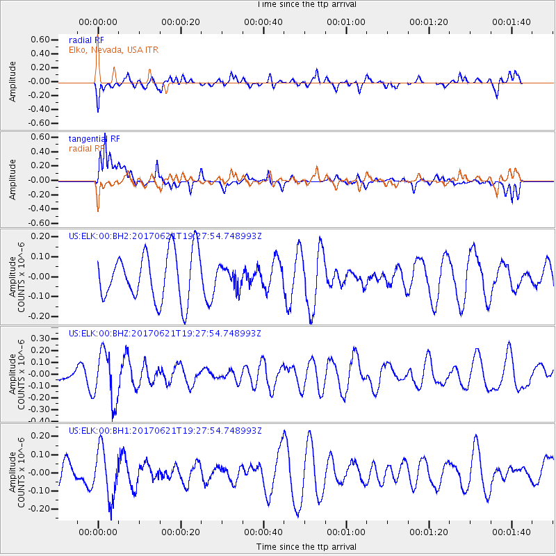
ELK Elko, Nevada, USA - Earthquake Result Viewer
*The percent match for this event was below the threshold and hence no stack was calculated.
| Earthquake location: |
Rat Islands, Aleutian Islands |
| Earthquake latitude/longitude: |
51.8/179.4 |
| Earthquake time(UTC): |
2017/06/21 (172) 19:20:26 GMT |
| Earthquake Depth: |
165 km |
| Earthquake Magnitude: |
5.5 Mb |
| Earthquake Catalog/Contributor: |
NEIC PDE/at |
|
| Network: |
US United States National Seismic Network |
| Station: |
ELK Elko, Nevada, USA |
| Lat/Lon: |
40.74 N/115.24 W |
| Elevation: |
2210 m |
|
| Distance: |
45.0 deg |
| Az: |
77.361 deg |
| Baz: |
307.165 deg |
| Ray Param: |
$rayparam |
*The percent match for this event was below the threshold and hence was not used in the summary stack. |
|
| Radial Match: |
39.383316 % |
| Radial Bump: |
400 |
| Transverse Match: |
69.334366 % |
| Transverse Bump: |
400 |
| SOD ConfigId: |
2140511 |
| Insert Time: |
2017-07-05 11:30:56.102 +0000 |
| GWidth: |
2.5 |
| Max Bumps: |
400 |
| Tol: |
0.001 |
|
Signal To Noise
| Channel | StoN | STA | LTA |
| US:ELK:00:BHZ:20170621T19:27:54.748993Z | 3.4188807 | 2.1736358E-7 | 6.357741E-8 |
| US:ELK:00:BH1:20170621T19:27:54.748993Z | 2.175968 | 1.3483024E-7 | 6.196334E-8 |
| US:ELK:00:BH2:20170621T19:27:54.748993Z | 0.4228539 | 5.1321614E-8 | 1.2136962E-7 |
| Arrivals |
| Ps | |
| PpPs | |
| PsPs/PpSs | |


