You are here: Home > Network List > RV - Regional Alberta Seismic Observatory for Earthquake Studies Network Stations List
> Station HSPGA Hill Springs, AB > Earthquake Result Viewer
HSPGA Hill Springs, AB - Earthquake Result Viewer
| Earthquake location: |
Near Coast Of Oaxaca, Mexico |
| Earthquake latitude/longitude: |
15.9/-95.9 |
| Earthquake time(UTC): |
2020/06/23 (175) 15:29:04 GMT |
| Earthquake Depth: |
20 km |
| Earthquake Magnitude: |
7.4 mww |
| Earthquake Catalog/Contributor: |
NEIC PDE/us |
|
| Network: |
RV Regional Alberta Seismic Observatory for Earthquake Studies Network |
| Station: |
HSPGA Hill Springs, AB |
| Lat/Lon: |
49.36 N/113.65 W |
| Elevation: |
1155 m |
|
| Distance: |
36.3 deg |
| Az: |
340.378 deg |
| Baz: |
150.387 deg |
| Ray Param: |
0.07674518 |
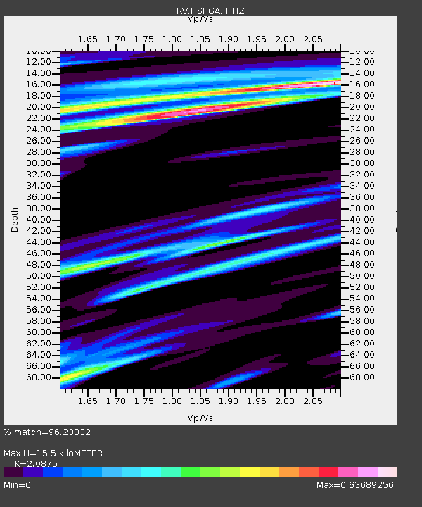
| Estimated Moho Depth: |
15.5 km |
| Estimated Crust Vp/Vs: |
2.09 |
| Assumed Crust Vp: |
6.178 km/s |
| Estimated Crust Vs: |
2.96 km/s |
| Estimated Crust Poisson's Ratio: |
0.35 |
|
| Radial Match: |
96.23332 % |
| Radial Bump: |
277 |
| Transverse Match: |
70.52371 % |
| Transverse Bump: |
400 |
| SOD ConfigId: |
21709731 |
| Insert Time: |
2020-07-07 15:46:51.712 +0000 |
| GWidth: |
2.5 |
| Max Bumps: |
400 |
| Tol: |
0.001 |
|

Signal To Noise
| Channel | StoN | STA | LTA |
| RV:HSPGA: :HHZ:20200623T15:35:36.149986Z | 44.272377 | 1.4878773E-5 | 3.360735E-7 |
| RV:HSPGA: :HHN:20200623T15:35:36.149986Z | 14.600039 | 5.80832E-6 | 3.9782913E-7 |
| RV:HSPGA: :HHE:20200623T15:35:36.149986Z | 9.073263 | 3.460606E-6 | 3.8140698E-7 |
| Arrivals |
| Ps | 2.9 SECOND |
| PpPs | 7.3 SECOND |
| PsPs/PpSs | 10 SECOND |


