You are here: Home > Network List > TA - USArray Transportable Network (new EarthScope stations) Stations List
> Station D23K Nanushuk River, AK USA > Earthquake Result Viewer
D23K Nanushuk River, AK USA - Earthquake Result Viewer
| Earthquake location: |
Near Coast Of Oaxaca, Mexico |
| Earthquake latitude/longitude: |
15.9/-95.9 |
| Earthquake time(UTC): |
2020/06/23 (175) 15:29:04 GMT |
| Earthquake Depth: |
20 km |
| Earthquake Magnitude: |
7.4 mww |
| Earthquake Catalog/Contributor: |
NEIC PDE/us |
|
| Network: |
TA USArray Transportable Network (new EarthScope stations) |
| Station: |
D23K Nanushuk River, AK USA |
| Lat/Lon: |
68.97 N/150.68 W |
| Elevation: |
406 m |
|
| Distance: |
62.9 deg |
| Az: |
340.668 deg |
| Baz: |
118.095 deg |
| Ray Param: |
0.059866693 |
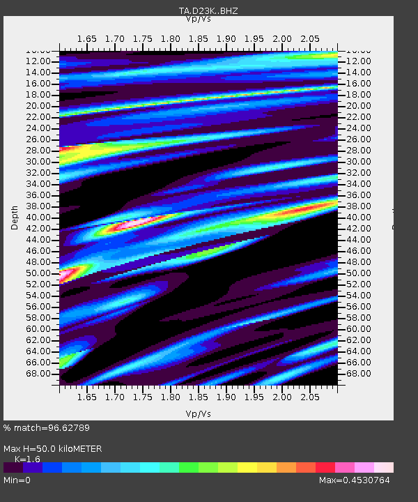
| Estimated Moho Depth: |
50.0 km |
| Estimated Crust Vp/Vs: |
1.60 |
| Assumed Crust Vp: |
6.221 km/s |
| Estimated Crust Vs: |
3.888 km/s |
| Estimated Crust Poisson's Ratio: |
0.18 |
|
| Radial Match: |
96.62789 % |
| Radial Bump: |
334 |
| Transverse Match: |
85.65717 % |
| Transverse Bump: |
400 |
| SOD ConfigId: |
21709731 |
| Insert Time: |
2020-07-07 15:47:33.501 +0000 |
| GWidth: |
2.5 |
| Max Bumps: |
400 |
| Tol: |
0.001 |
|
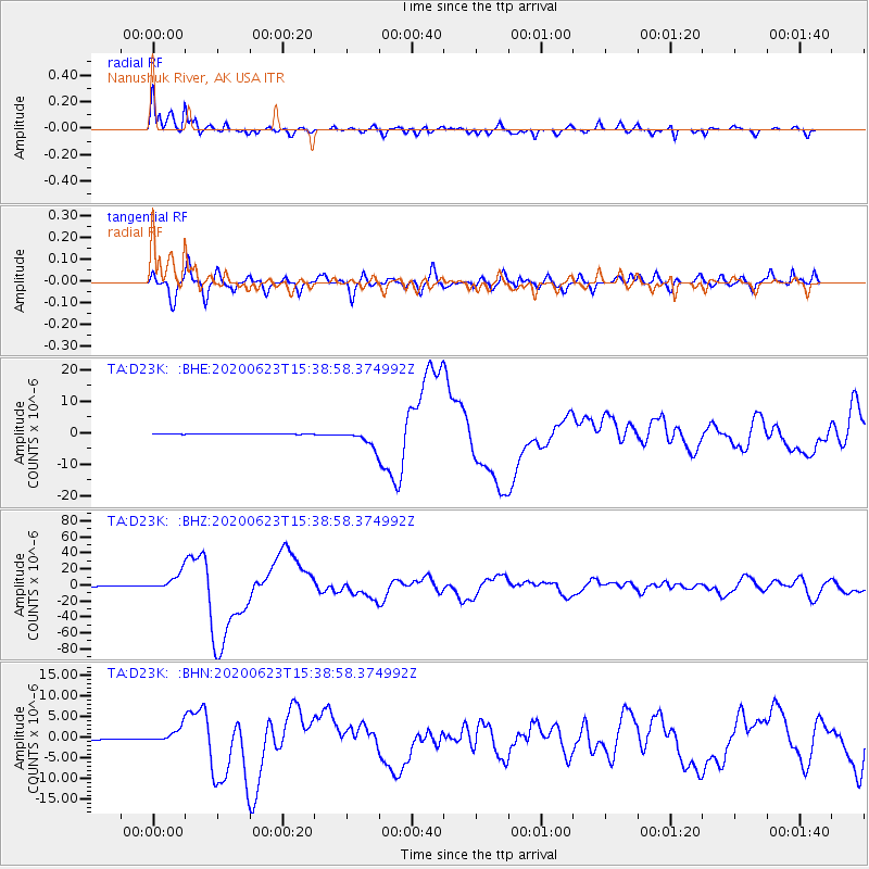
Signal To Noise
| Channel | StoN | STA | LTA |
| TA:D23K: :BHZ:20200623T15:38:58.374992Z | 87.12238 | 1.0879435E-5 | 1.2487531E-7 |
| TA:D23K: :BHN:20200623T15:38:58.374992Z | 41.56201 | 1.8680176E-6 | 4.4945313E-8 |
| TA:D23K: :BHE:20200623T15:38:58.374992Z | 45.812313 | 2.7583876E-6 | 6.021062E-8 |
| Arrivals |
| Ps | 5.0 SECOND |
| PpPs | 20 SECOND |
| PsPs/PpSs | 25 SECOND |


