You are here: Home > Network List > TA - USArray Transportable Network (new EarthScope stations) Stations List
> Station E17K Hotham Inlet, AK, USA > Earthquake Result Viewer
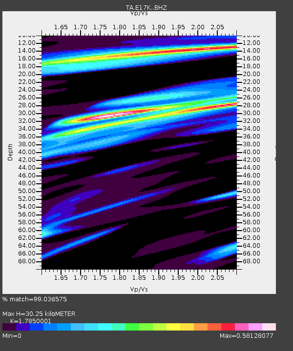
E17K Hotham Inlet, AK, USA - Earthquake Result Viewer
| Earthquake location: |
Near Coast Of Oaxaca, Mexico |
| Earthquake latitude/longitude: |
15.9/-95.9 |
| Earthquake time(UTC): |
2020/06/23 (175) 15:29:04 GMT |
| Earthquake Depth: |
20 km |
| Earthquake Magnitude: |
7.4 mww |
| Earthquake Catalog/Contributor: |
NEIC PDE/us |
|
| Network: |
TA USArray Transportable Network (new EarthScope stations) |
| Station: |
E17K Hotham Inlet, AK, USA |
| Lat/Lon: |
67.08 N/161.83 W |
| Elevation: |
233 m |
|
| Distance: |
66.1 deg |
| Az: |
336.986 deg |
| Baz: |
106.179 deg |
| Ray Param: |
0.05781143 |
| Estimated Moho Depth: |
30.25 km |
| Estimated Crust Vp/Vs: |
1.79 |
| Assumed Crust Vp: |
6.276 km/s |
| Estimated Crust Vs: |
3.516 km/s |
| Estimated Crust Poisson's Ratio: |
0.27 |
|
| Radial Match: |
99.036575 % |
| Radial Bump: |
202 |
| Transverse Match: |
97.20996 % |
| Transverse Bump: |
329 |
| SOD ConfigId: |
21709731 |
| Insert Time: |
2020-07-07 15:47:40.566 +0000 |
| GWidth: |
2.5 |
| Max Bumps: |
400 |
| Tol: |
0.001 |
|

Signal To Noise
| Channel | StoN | STA | LTA |
| TA:E17K: :BHZ:20200623T15:39:19.04998Z | 84.639 | 1.2001993E-5 | 1.4180216E-7 |
| TA:E17K: :BHN:20200623T15:39:19.04998Z | 23.50402 | 1.8579102E-6 | 7.904649E-8 |
| TA:E17K: :BHE:20200623T15:39:19.04998Z | 60.411465 | 5.3162794E-6 | 8.8001165E-8 |
| Arrivals |
| Ps | 3.9 SECOND |
| PpPs | 13 SECOND |
| PsPs/PpSs | 17 SECOND |


