You are here: Home > Network List > TA - USArray Transportable Network (new EarthScope stations) Stations List
> Station M24K Tolsona, Glennallen, AK, USA > Earthquake Result Viewer
M24K Tolsona, Glennallen, AK, USA - Earthquake Result Viewer
| Earthquake location: |
Near Coast Of Oaxaca, Mexico |
| Earthquake latitude/longitude: |
15.9/-95.9 |
| Earthquake time(UTC): |
2020/06/23 (175) 15:29:04 GMT |
| Earthquake Depth: |
20 km |
| Earthquake Magnitude: |
7.4 mww |
| Earthquake Catalog/Contributor: |
NEIC PDE/us |
|
| Network: |
TA USArray Transportable Network (new EarthScope stations) |
| Station: |
M24K Tolsona, Glennallen, AK, USA |
| Lat/Lon: |
62.11 N/146.18 W |
| Elevation: |
908 m |
|
| Distance: |
58.0 deg |
| Az: |
334.764 deg |
| Baz: |
119.285 deg |
| Ray Param: |
0.063118815 |
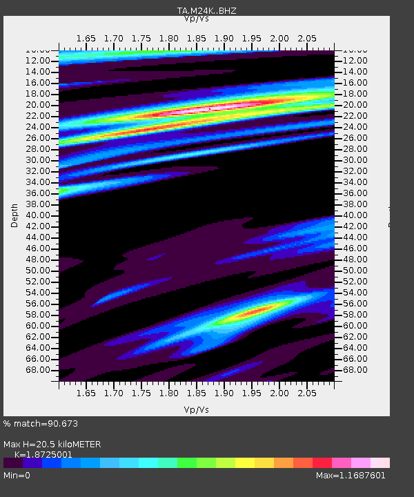
| Estimated Moho Depth: |
20.5 km |
| Estimated Crust Vp/Vs: |
1.87 |
| Assumed Crust Vp: |
6.566 km/s |
| Estimated Crust Vs: |
3.507 km/s |
| Estimated Crust Poisson's Ratio: |
0.30 |
|
| Radial Match: |
90.673 % |
| Radial Bump: |
400 |
| Transverse Match: |
81.026695 % |
| Transverse Bump: |
400 |
| SOD ConfigId: |
21709731 |
| Insert Time: |
2020-07-07 15:49:15.359 +0000 |
| GWidth: |
2.5 |
| Max Bumps: |
400 |
| Tol: |
0.001 |
|
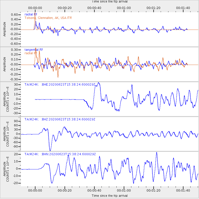
Signal To Noise
| Channel | StoN | STA | LTA |
| TA:M24K: :BHZ:20200623T15:38:24.600029Z | 61.35615 | 7.9854235E-6 | 1.301487E-7 |
| TA:M24K: :BHN:20200623T15:38:24.600029Z | 5.539665 | 8.535089E-7 | 1.5407228E-7 |
| TA:M24K: :BHE:20200623T15:38:24.600029Z | 18.603521 | 2.2241286E-6 | 1.1955417E-7 |
| Arrivals |
| Ps | 2.9 SECOND |
| PpPs | 8.5 SECOND |
| PsPs/PpSs | 11 SECOND |


