You are here: Home > Network List > TA - USArray Transportable Network (new EarthScope stations) Stations List
> Station N30M Aishikik Lake, Yukon, CAN > Earthquake Result Viewer
N30M Aishikik Lake, Yukon, CAN - Earthquake Result Viewer
| Earthquake location: |
Near Coast Of Oaxaca, Mexico |
| Earthquake latitude/longitude: |
15.9/-95.9 |
| Earthquake time(UTC): |
2020/06/23 (175) 15:29:04 GMT |
| Earthquake Depth: |
20 km |
| Earthquake Magnitude: |
7.4 mww |
| Earthquake Catalog/Contributor: |
NEIC PDE/us |
|
| Network: |
TA USArray Transportable Network (new EarthScope stations) |
| Station: |
N30M Aishikik Lake, Yukon, CAN |
| Lat/Lon: |
61.46 N/137.09 W |
| Elevation: |
941 m |
|
| Distance: |
54.0 deg |
| Az: |
337.019 deg |
| Baz: |
128.544 deg |
| Ray Param: |
0.06567615 |
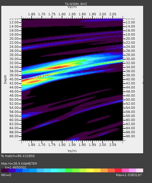
| Estimated Moho Depth: |
38.5 km |
| Estimated Crust Vp/Vs: |
1.69 |
| Assumed Crust Vp: |
6.566 km/s |
| Estimated Crust Vs: |
3.897 km/s |
| Estimated Crust Poisson's Ratio: |
0.23 |
|
| Radial Match: |
98.432655 % |
| Radial Bump: |
238 |
| Transverse Match: |
88.232635 % |
| Transverse Bump: |
400 |
| SOD ConfigId: |
21709731 |
| Insert Time: |
2020-07-07 15:49:26.724 +0000 |
| GWidth: |
2.5 |
| Max Bumps: |
400 |
| Tol: |
0.001 |
|

Signal To Noise
| Channel | StoN | STA | LTA |
| TA:N30M: :BHZ:20200623T15:37:56.450004Z | 62.318245 | 5.3033946E-6 | 8.5101796E-8 |
| TA:N30M: :BHN:20200623T15:37:56.450004Z | 21.8665 | 1.4836934E-6 | 6.785235E-8 |
| TA:N30M: :BHE:20200623T15:37:56.450004Z | 37.095234 | 2.3073633E-6 | 6.220107E-8 |
| Arrivals |
| Ps | 4.3 SECOND |
| PpPs | 15 SECOND |
| PsPs/PpSs | 19 SECOND |


