You are here: Home > Network List > TA - USArray Transportable Network (new EarthScope stations) Stations List
> Station S14K Fog Glacier, AK, USA > Earthquake Result Viewer
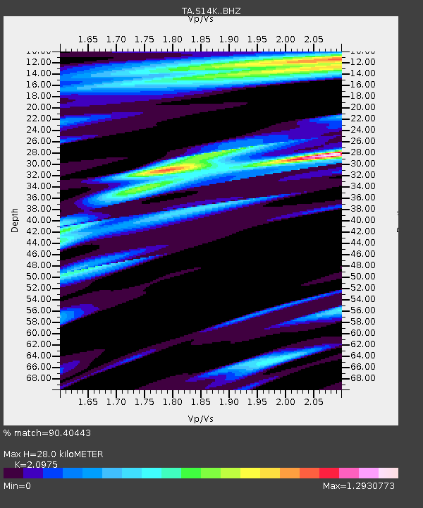
S14K Fog Glacier, AK, USA - Earthquake Result Viewer
| Earthquake location: |
Near Coast Of Oaxaca, Mexico |
| Earthquake latitude/longitude: |
15.9/-95.9 |
| Earthquake time(UTC): |
2020/06/23 (175) 15:29:04 GMT |
| Earthquake Depth: |
20 km |
| Earthquake Magnitude: |
7.4 mww |
| Earthquake Catalog/Contributor: |
NEIC PDE/us |
|
| Network: |
TA USArray Transportable Network (new EarthScope stations) |
| Station: |
S14K Fog Glacier, AK, USA |
| Lat/Lon: |
56.28 N/159.55 W |
| Elevation: |
1059 m |
|
| Distance: |
62.3 deg |
| Az: |
325.652 deg |
| Baz: |
103.239 deg |
| Ray Param: |
0.060298722 |
| Estimated Moho Depth: |
28.0 km |
| Estimated Crust Vp/Vs: |
2.10 |
| Assumed Crust Vp: |
6.134 km/s |
| Estimated Crust Vs: |
2.924 km/s |
| Estimated Crust Poisson's Ratio: |
0.35 |
|
| Radial Match: |
90.40443 % |
| Radial Bump: |
400 |
| Transverse Match: |
84.621025 % |
| Transverse Bump: |
400 |
| SOD ConfigId: |
21709731 |
| Insert Time: |
2020-07-07 15:49:48.757 +0000 |
| GWidth: |
2.5 |
| Max Bumps: |
400 |
| Tol: |
0.001 |
|

Signal To Noise
| Channel | StoN | STA | LTA |
| TA:S14K: :BHZ:20200623T15:38:54.100029Z | 65.561035 | 1.3893437E-5 | 2.1191607E-7 |
| TA:S14K: :BHN:20200623T15:38:54.100029Z | 3.3922489 | 1.1593457E-6 | 3.4176315E-7 |
| TA:S14K: :BHE:20200623T15:38:54.100029Z | 14.731948 | 4.9317755E-6 | 3.3476738E-7 |
| Arrivals |
| Ps | 5.2 SECOND |
| PpPs | 14 SECOND |
| PsPs/PpSs | 19 SECOND |


