You are here: Home > Network List > TA - USArray Transportable Network (new EarthScope stations) Stations List
> Station U35K Hyder, AK, USA > Earthquake Result Viewer
U35K Hyder, AK, USA - Earthquake Result Viewer
| Earthquake location: |
Near Coast Of Oaxaca, Mexico |
| Earthquake latitude/longitude: |
15.9/-95.9 |
| Earthquake time(UTC): |
2020/06/23 (175) 15:29:04 GMT |
| Earthquake Depth: |
20 km |
| Earthquake Magnitude: |
7.4 mww |
| Earthquake Catalog/Contributor: |
NEIC PDE/us |
|
| Network: |
TA USArray Transportable Network (new EarthScope stations) |
| Station: |
U35K Hyder, AK, USA |
| Lat/Lon: |
55.92 N/130.03 W |
| Elevation: |
17 m |
|
| Distance: |
47.6 deg |
| Az: |
334.712 deg |
| Baz: |
133.118 deg |
| Ray Param: |
0.06986223 |
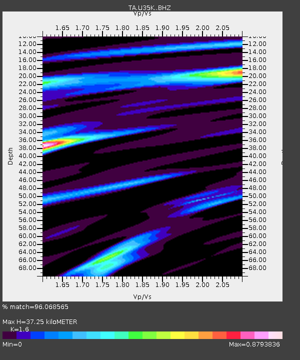
| Estimated Moho Depth: |
37.25 km |
| Estimated Crust Vp/Vs: |
1.60 |
| Assumed Crust Vp: |
6.545 km/s |
| Estimated Crust Vs: |
4.091 km/s |
| Estimated Crust Poisson's Ratio: |
0.18 |
|
| Radial Match: |
96.068565 % |
| Radial Bump: |
400 |
| Transverse Match: |
74.42806 % |
| Transverse Bump: |
400 |
| SOD ConfigId: |
21709731 |
| Insert Time: |
2020-07-07 15:49:54.334 +0000 |
| GWidth: |
2.5 |
| Max Bumps: |
400 |
| Tol: |
0.001 |
|

Signal To Noise
| Channel | StoN | STA | LTA |
| TA:U35K: :BHZ:20200623T15:37:08.17501Z | 18.302256 | 5.2726155E-6 | 2.8808557E-7 |
| TA:U35K: :BHN:20200623T15:37:08.17501Z | 6.165737 | 1.6655397E-6 | 2.7012823E-7 |
| TA:U35K: :BHE:20200623T15:37:08.17501Z | 5.4896016 | 1.6435475E-6 | 2.9939287E-7 |
| Arrivals |
| Ps | 3.7 SECOND |
| PpPs | 14 SECOND |
| PsPs/PpSs | 17 SECOND |


