You are here: Home > Network List > KN - Kyrgyz Seismic Telemetry Network Stations List
> Station ULHL KN.ULHL > Earthquake Result Viewer
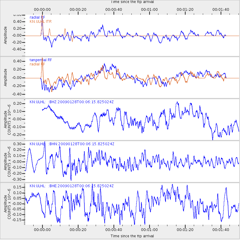
ULHL KN.ULHL - Earthquake Result Viewer
*The percent match for this event was below the threshold and hence no stack was calculated.
| Earthquake location: |
Komandorskiye Ostrova Region |
| Earthquake latitude/longitude: |
55.5/164.3 |
| Earthquake time(UTC): |
2009/01/27 (027) 23:57:13 GMT |
| Earthquake Depth: |
24 km |
| Earthquake Magnitude: |
5.5 MW, 5.2 MS, 5.4 MB |
| Earthquake Catalog/Contributor: |
WHDF/NEIC |
|
| Network: |
KN Kyrgyz Seismic Telemetry Network |
| Station: |
ULHL KN.ULHL |
| Lat/Lon: |
42.25 N/76.24 E |
| Elevation: |
2040 m |
|
| Distance: |
55.6 deg |
| Az: |
295.883 deg |
| Baz: |
43.536 deg |
| Ray Param: |
$rayparam |
*The percent match for this event was below the threshold and hence was not used in the summary stack. |
|
| Radial Match: |
62.107834 % |
| Radial Bump: |
400 |
| Transverse Match: |
46.3002 % |
| Transverse Bump: |
400 |
| SOD ConfigId: |
2658 |
| Insert Time: |
2010-03-08 22:05:12.788 +0000 |
| GWidth: |
2.5 |
| Max Bumps: |
400 |
| Tol: |
0.001 |
|
Signal To Noise
| Channel | StoN | STA | LTA |
| KN:ULHL: :BHN:20090128T00:06:15.825024Z | 1.7451118 | 1.4648715E-7 | 8.3941416E-8 |
| KN:ULHL: :BHE:20090128T00:06:15.825024Z | 1.7884511 | 7.8465625E-8 | 4.387351E-8 |
| KN:ULHL: :BHZ:20090128T00:06:15.825024Z | 0.73228866 | 7.343176E-8 | 1.0027706E-7 |
| Arrivals |
| Ps | |
| PpPs | |
| PsPs/PpSs | |


