You are here: Home > Network List > KN - Kyrgyz Seismic Telemetry Network Stations List
> Station ULHL KN.ULHL > Earthquake Result Viewer
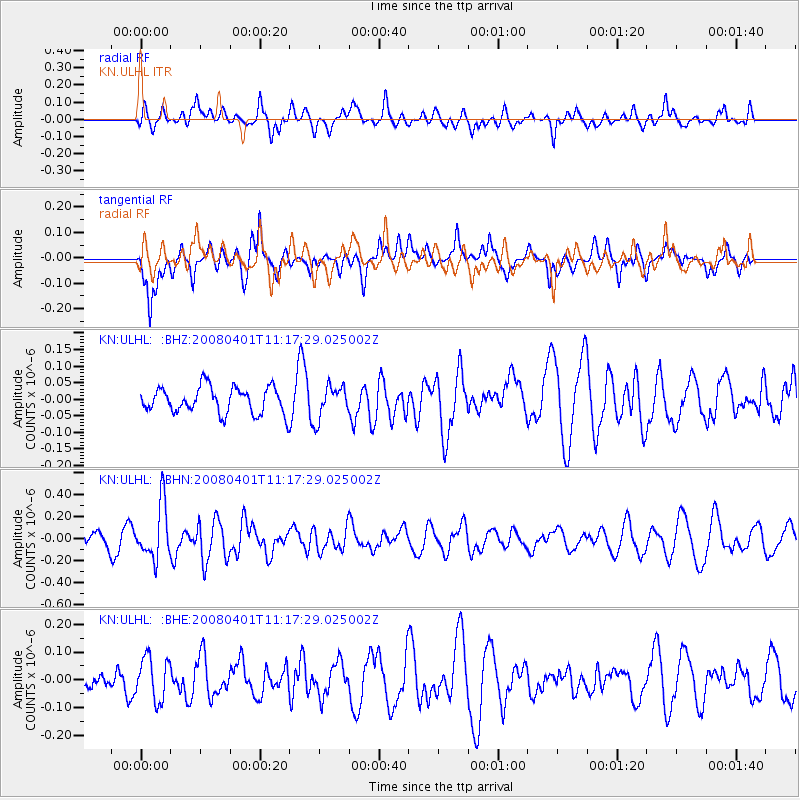
ULHL KN.ULHL - Earthquake Result Viewer
*The percent match for this event was below the threshold and hence no stack was calculated.
| Earthquake location: |
Southwest Indian Ridge |
| Earthquake latitude/longitude: |
-38.9/46.3 |
| Earthquake time(UTC): |
2008/04/01 (092) 11:05:23 GMT |
| Earthquake Depth: |
10 km |
| Earthquake Magnitude: |
5.5 MB, 5.4 MW |
| Earthquake Catalog/Contributor: |
WHDF/NEIC |
|
| Network: |
KN Kyrgyz Seismic Telemetry Network |
| Station: |
ULHL KN.ULHL |
| Lat/Lon: |
42.25 N/76.24 E |
| Elevation: |
2040 m |
|
| Distance: |
85.3 deg |
| Az: |
21.825 deg |
| Baz: |
202.983 deg |
| Ray Param: |
$rayparam |
*The percent match for this event was below the threshold and hence was not used in the summary stack. |
|
| Radial Match: |
50.497375 % |
| Radial Bump: |
400 |
| Transverse Match: |
64.63443 % |
| Transverse Bump: |
400 |
| SOD ConfigId: |
2504 |
| Insert Time: |
2010-03-08 22:05:19.478 +0000 |
| GWidth: |
2.5 |
| Max Bumps: |
400 |
| Tol: |
0.001 |
|
Signal To Noise
| Channel | StoN | STA | LTA |
| KN:ULHL: :BHN:20080401T11:17:29.025002Z | 3.5662324 | 2.472487E-7 | 6.9330504E-8 |
| KN:ULHL: :BHE:20080401T11:17:29.025002Z | 1.5715553 | 7.822464E-8 | 4.9775306E-8 |
| KN:ULHL: :BHZ:20080401T11:17:29.025002Z | 1.2571526 | 4.9478576E-8 | 3.9357655E-8 |
| Arrivals |
| Ps | |
| PpPs | |
| PsPs/PpSs | |


