You are here: Home > Network List > US - United States National Seismic Network Stations List
> Station EGMT Eagleton, Montana, USA > Earthquake Result Viewer
EGMT Eagleton, Montana, USA - Earthquake Result Viewer
| Earthquake location: |
Near Coast Of Oaxaca, Mexico |
| Earthquake latitude/longitude: |
15.9/-95.9 |
| Earthquake time(UTC): |
2020/06/23 (175) 15:29:04 GMT |
| Earthquake Depth: |
20 km |
| Earthquake Magnitude: |
7.4 mww |
| Earthquake Catalog/Contributor: |
NEIC PDE/us |
|
| Network: |
US United States National Seismic Network |
| Station: |
EGMT Eagleton, Montana, USA |
| Lat/Lon: |
48.02 N/109.75 W |
| Elevation: |
1055 m |
|
| Distance: |
34.0 deg |
| Az: |
343.325 deg |
| Baz: |
155.717 deg |
| Ray Param: |
0.077953205 |
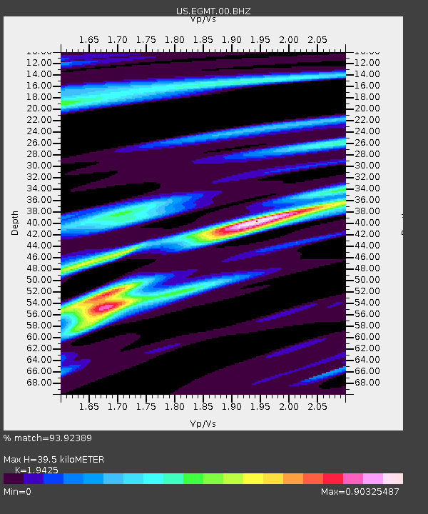
| Estimated Moho Depth: |
39.5 km |
| Estimated Crust Vp/Vs: |
1.94 |
| Assumed Crust Vp: |
6.438 km/s |
| Estimated Crust Vs: |
3.314 km/s |
| Estimated Crust Poisson's Ratio: |
0.32 |
|
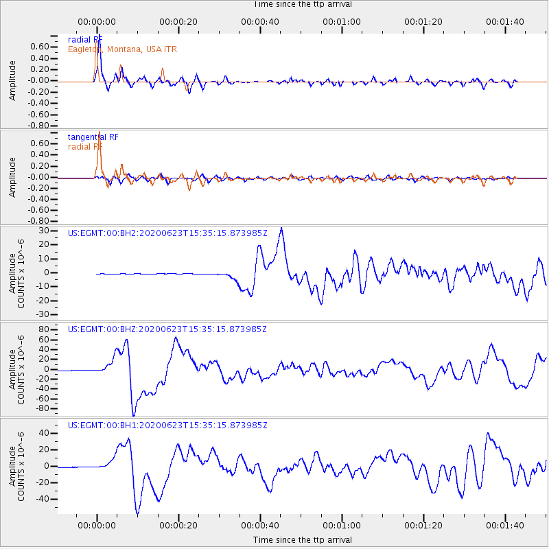
| Radial Match: |
93.92389 % |
| Radial Bump: |
326 |
| Transverse Match: |
74.187164 % |
| Transverse Bump: |
400 |
| SOD ConfigId: |
21709731 |
| Insert Time: |
2020-07-07 15:51:04.769 +0000 |
| GWidth: |
2.5 |
| Max Bumps: |
400 |
| Tol: |
0.001 |
|
Signal To Noise
| Channel | StoN | STA | LTA |
| US:EGMT:00:BHZ:20200623T15:35:15.873985Z | 110.40161 | 1.6805128E-5 | 1.5221815E-7 |
| US:EGMT:00:BH1:20200623T15:35:15.873985Z | 35.443203 | 7.167546E-6 | 2.0222625E-7 |
| US:EGMT:00:BH2:20200623T15:35:15.873985Z | 37.422413 | 3.155538E-6 | 8.432214E-8 |
| Arrivals |
| Ps | 6.2 SECOND |
| PpPs | 17 SECOND |
| PsPs/PpSs | 23 SECOND |


