You are here: Home > Network List > US - United States National Seismic Network Stations List
> Station HAWA Hanford, Washington, USA > Earthquake Result Viewer
HAWA Hanford, Washington, USA - Earthquake Result Viewer
| Earthquake location: |
Near Coast Of Oaxaca, Mexico |
| Earthquake latitude/longitude: |
15.9/-95.9 |
| Earthquake time(UTC): |
2020/06/23 (175) 15:29:04 GMT |
| Earthquake Depth: |
20 km |
| Earthquake Magnitude: |
7.4 mww |
| Earthquake Catalog/Contributor: |
NEIC PDE/us |
|
| Network: |
US United States National Seismic Network |
| Station: |
HAWA Hanford, Washington, USA |
| Lat/Lon: |
46.39 N/119.53 W |
| Elevation: |
364 m |
|
| Distance: |
36.2 deg |
| Az: |
332.014 deg |
| Baz: |
139.287 deg |
| Ray Param: |
0.07682234 |
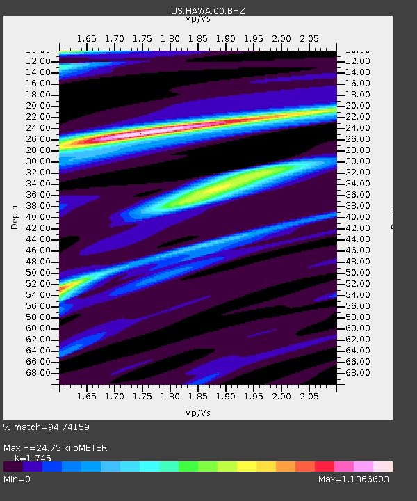
| Estimated Moho Depth: |
24.75 km |
| Estimated Crust Vp/Vs: |
1.75 |
| Assumed Crust Vp: |
6.419 km/s |
| Estimated Crust Vs: |
3.679 km/s |
| Estimated Crust Poisson's Ratio: |
0.26 |
|
| Radial Match: |
94.74159 % |
| Radial Bump: |
291 |
| Transverse Match: |
69.90631 % |
| Transverse Bump: |
400 |
| SOD ConfigId: |
21709731 |
| Insert Time: |
2020-07-07 15:51:07.828 +0000 |
| GWidth: |
2.5 |
| Max Bumps: |
400 |
| Tol: |
0.001 |
|

Signal To Noise
| Channel | StoN | STA | LTA |
| US:HAWA:00:BHZ:20200623T15:35:34.92501Z | 96.76317 | 1.4232711E-5 | 1.470881E-7 |
| US:HAWA:00:BH1:20200623T15:35:34.92501Z | 30.906815 | 5.7526704E-6 | 1.8612953E-7 |
| US:HAWA:00:BH2:20200623T15:35:34.92501Z | 47.92654 | 5.956133E-6 | 1.242763E-7 |
| Arrivals |
| Ps | 3.1 SECOND |
| PpPs | 9.8 SECOND |
| PsPs/PpSs | 13 SECOND |


