You are here: Home > Network List > US - United States National Seismic Network Stations List
> Station LONY Lake Ozonia, New York, USA > Earthquake Result Viewer
LONY Lake Ozonia, New York, USA - Earthquake Result Viewer
| Earthquake location: |
Near Coast Of Oaxaca, Mexico |
| Earthquake latitude/longitude: |
15.9/-95.9 |
| Earthquake time(UTC): |
2020/06/23 (175) 15:29:04 GMT |
| Earthquake Depth: |
20 km |
| Earthquake Magnitude: |
7.4 mww |
| Earthquake Catalog/Contributor: |
NEIC PDE/us |
|
| Network: |
US United States National Seismic Network |
| Station: |
LONY Lake Ozonia, New York, USA |
| Lat/Lon: |
44.62 N/74.58 W |
| Elevation: |
440 m |
|
| Distance: |
33.8 deg |
| Az: |
27.857 deg |
| Baz: |
219.012 deg |
| Ray Param: |
0.07802777 |
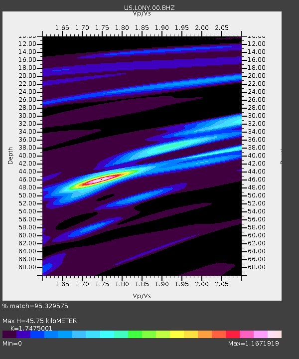
| Estimated Moho Depth: |
45.75 km |
| Estimated Crust Vp/Vs: |
1.75 |
| Assumed Crust Vp: |
6.419 km/s |
| Estimated Crust Vs: |
3.673 km/s |
| Estimated Crust Poisson's Ratio: |
0.26 |
|
| Radial Match: |
95.329575 % |
| Radial Bump: |
256 |
| Transverse Match: |
90.99708 % |
| Transverse Bump: |
340 |
| SOD ConfigId: |
21709731 |
| Insert Time: |
2020-07-07 15:51:14.100 +0000 |
| GWidth: |
2.5 |
| Max Bumps: |
400 |
| Tol: |
0.001 |
|
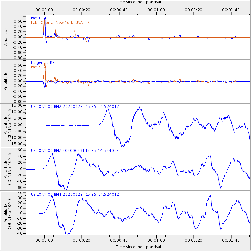
Signal To Noise
| Channel | StoN | STA | LTA |
| US:LONY:00:BHZ:20200623T15:35:14.52401Z | 141.69014 | 3.106877E-5 | 2.1927264E-7 |
| US:LONY:00:BH1:20200623T15:35:14.52401Z | 73.90679 | 2.008707E-5 | 2.7178928E-7 |
| US:LONY:00:BH2:20200623T15:35:14.52401Z | 66.668175 | 7.790655E-6 | 1.1685719E-7 |
| Arrivals |
| Ps | 5.8 SECOND |
| PpPs | 18 SECOND |
| PsPs/PpSs | 24 SECOND |


