You are here: Home > Network List > US - United States National Seismic Network Stations List
> Station LKWY Lake (Yellowstone--Lake), Wyoming, USA > Earthquake Result Viewer
LKWY Lake (Yellowstone--Lake), Wyoming, USA - Earthquake Result Viewer

| Earthquake location: |
Near Coast Of Oaxaca, Mexico |
| Earthquake latitude/longitude: |
15.9/-95.9 |
| Earthquake time(UTC): |
2020/06/23 (175) 15:29:04 GMT |
| Earthquake Depth: |
20 km |
| Earthquake Magnitude: |
7.4 mww |
| Earthquake Catalog/Contributor: |
NEIC PDE/us |
|
| Network: |
US United States National Seismic Network |
| Station: |
LKWY Lake (Yellowstone--Lake), Wyoming, USA |
| Lat/Lon: |
44.57 N/110.40 W |
| Elevation: |
2424 m |
|
| Distance: |
31.1 deg |
| Az: |
339.753 deg |
| Baz: |
152.239 deg |
| Ray Param: |
0.07920048 |
| Estimated Moho Depth: |
15.25 km |
| Estimated Crust Vp/Vs: |
2.09 |
| Assumed Crust Vp: |
6.35 km/s |
| Estimated Crust Vs: |
3.038 km/s |
| Estimated Crust Poisson's Ratio: |
0.35 |
|
| Radial Match: |
87.04116 % |
| Radial Bump: |
400 |
| Transverse Match: |
72.00782 % |
| Transverse Bump: |
400 |
| SOD ConfigId: |
21709731 |
| Insert Time: |
2020-07-07 15:51:14.369 +0000 |
| GWidth: |
2.5 |
| Max Bumps: |
400 |
| Tol: |
0.001 |
|
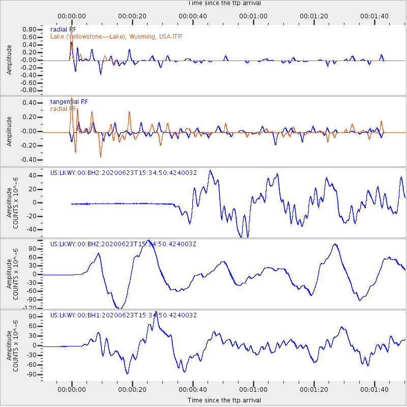
Signal To Noise
| Channel | StoN | STA | LTA |
| US:LKWY:00:BHZ:20200623T15:34:50.424003Z | 10.788682 | 5.1427296E-6 | 4.7667822E-7 |
| US:LKWY:00:BH1:20200623T15:34:50.424003Z | 21.404573 | 2.7818962E-6 | 1.2996738E-7 |
| US:LKWY:00:BH2:20200623T15:34:50.424003Z | 6.68761 | 1.8712605E-6 | 2.7981005E-7 |
| Arrivals |
| Ps | 2.8 SECOND |
| PpPs | 6.9 SECOND |
| PsPs/PpSs | 9.7 SECOND |


