You are here: Home > Network List > US - United States National Seismic Network Stations List
> Station WRAK Wrangell Island, Southeastern Alaska, Alaska, USA > Earthquake Result Viewer
WRAK Wrangell Island, Southeastern Alaska, Alaska, USA - Earthquake Result Viewer
| Earthquake location: |
Near Coast Of Oaxaca, Mexico |
| Earthquake latitude/longitude: |
15.9/-95.9 |
| Earthquake time(UTC): |
2020/06/23 (175) 15:29:04 GMT |
| Earthquake Depth: |
20 km |
| Earthquake Magnitude: |
7.4 mww |
| Earthquake Catalog/Contributor: |
NEIC PDE/us |
|
| Network: |
US United States National Seismic Network |
| Station: |
WRAK Wrangell Island, Southeastern Alaska, Alaska, USA |
| Lat/Lon: |
56.42 N/132.35 W |
| Elevation: |
81 m |
|
| Distance: |
48.9 deg |
| Az: |
334.053 deg |
| Baz: |
130.755 deg |
| Ray Param: |
0.06901565 |
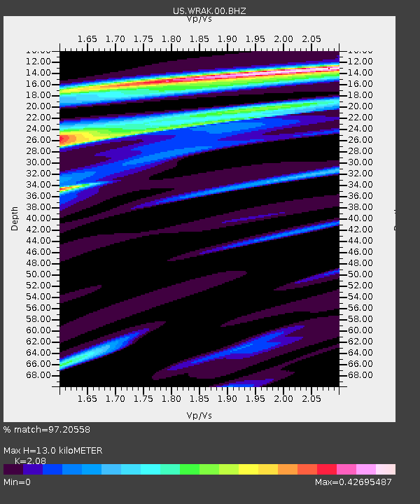
| Estimated Moho Depth: |
13.0 km |
| Estimated Crust Vp/Vs: |
2.08 |
| Assumed Crust Vp: |
6.597 km/s |
| Estimated Crust Vs: |
3.172 km/s |
| Estimated Crust Poisson's Ratio: |
0.35 |
|
| Radial Match: |
97.20558 % |
| Radial Bump: |
356 |
| Transverse Match: |
81.20528 % |
| Transverse Bump: |
400 |
| SOD ConfigId: |
21709731 |
| Insert Time: |
2020-07-07 15:51:22.256 +0000 |
| GWidth: |
2.5 |
| Max Bumps: |
400 |
| Tol: |
0.001 |
|

Signal To Noise
| Channel | StoN | STA | LTA |
| US:WRAK:00:BHZ:20200623T15:37:18.200004Z | 36.271194 | 6.089344E-6 | 1.6788375E-7 |
| US:WRAK:00:BH1:20200623T15:37:18.200004Z | 16.487316 | 2.238759E-6 | 1.3578673E-7 |
| US:WRAK:00:BH2:20200623T15:37:18.200004Z | 12.872861 | 2.2914141E-6 | 1.780035E-7 |
| Arrivals |
| Ps | 2.2 SECOND |
| PpPs | 5.8 SECOND |
| PsPs/PpSs | 8.0 SECOND |


