You are here: Home > Network List > UW - Pacific Northwest Regional Seismic Network Stations List
> Station HOOD Mt Hood Meadows, OR CREST BB SMO > Earthquake Result Viewer
HOOD Mt Hood Meadows, OR CREST BB SMO - Earthquake Result Viewer
| Earthquake location: |
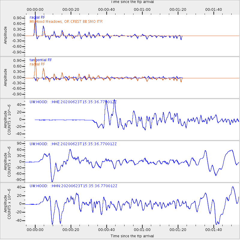
Near Coast Of Oaxaca, Mexico |
| Earthquake latitude/longitude: |
15.9/-95.9 |
| Earthquake time(UTC): |
2020/06/23 (175) 15:29:04 GMT |
| Earthquake Depth: |
20 km |
| Earthquake Magnitude: |
7.4 mww |
| Earthquake Catalog/Contributor: |
NEIC PDE/us |
|
| Network: |
UW Pacific Northwest Regional Seismic Network |
| Station: |
HOOD Mt Hood Meadows, OR CREST BB SMO |
| Lat/Lon: |
45.32 N/121.65 W |
| Elevation: |
1520 m |
|
| Distance: |
36.4 deg |
| Az: |
328.947 deg |
| Baz: |
135.298 deg |
| Ray Param: |
0.076705724 |
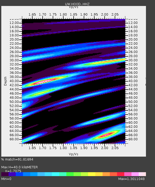
| Estimated Moho Depth: |
40.0 km |
| Estimated Crust Vp/Vs: |
1.71 |
| Assumed Crust Vp: |
6.597 km/s |
| Estimated Crust Vs: |
3.864 km/s |
| Estimated Crust Poisson's Ratio: |
0.24 |
|
| Radial Match: |
91.81694 % |
| Radial Bump: |
373 |
| Transverse Match: |
70.228676 % |
| Transverse Bump: |
400 |
| SOD ConfigId: |
21709731 |
| Insert Time: |
2020-07-07 15:51:54.490 +0000 |
| GWidth: |
2.5 |
| Max Bumps: |
400 |
| Tol: |
0.001 |
|
Signal To Noise
| Channel | StoN | STA | LTA |
| UW:HOOD: :HHZ:20200623T15:35:36.770012Z | 65.96615 | 1.0382579E-5 | 1.5739253E-7 |
| UW:HOOD: :HHN:20200623T15:35:36.770012Z | 28.230324 | 3.9275333E-6 | 1.3912464E-7 |
| UW:HOOD: :HHE:20200623T15:35:36.770012Z | 27.949286 | 4.241089E-6 | 1.517423E-7 |
| Arrivals |
| Ps | 4.7 SECOND |
| PpPs | 15 SECOND |
| PsPs/PpSs | 20 SECOND |


