You are here: Home > Network List > UW - Pacific Northwest Regional Seismic Network Stations List
> Station IRON Crane, OR, USA > Earthquake Result Viewer
IRON Crane, OR, USA - Earthquake Result Viewer
| Earthquake location: |
Near Coast Of Oaxaca, Mexico |
| Earthquake latitude/longitude: |
15.9/-95.9 |
| Earthquake time(UTC): |
2020/06/23 (175) 15:29:04 GMT |
| Earthquake Depth: |
20 km |
| Earthquake Magnitude: |
7.4 mww |
| Earthquake Catalog/Contributor: |
NEIC PDE/us |
|
| Network: |
UW Pacific Northwest Regional Seismic Network |
| Station: |
IRON Crane, OR, USA |
| Lat/Lon: |
43.36 N/118.47 W |
| Elevation: |
1226 m |
|
| Distance: |
33.4 deg |
| Az: |
329.489 deg |
| Baz: |
137.958 deg |
| Ray Param: |
0.0782146 |
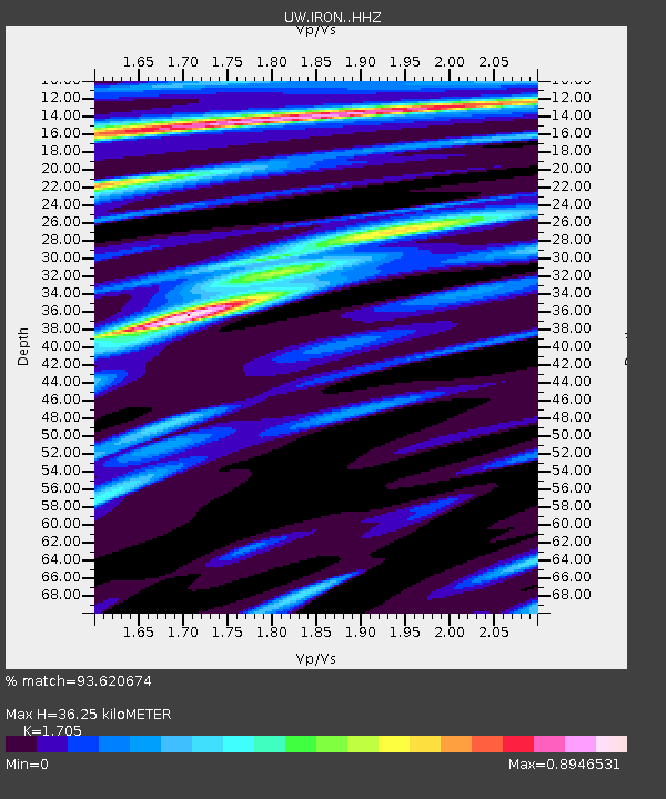
| Estimated Moho Depth: |
36.25 km |
| Estimated Crust Vp/Vs: |
1.71 |
| Assumed Crust Vp: |
6.279 km/s |
| Estimated Crust Vs: |
3.682 km/s |
| Estimated Crust Poisson's Ratio: |
0.24 |
|
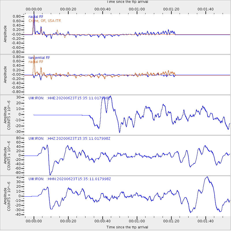
| Radial Match: |
93.620674 % |
| Radial Bump: |
400 |
| Transverse Match: |
80.67618 % |
| Transverse Bump: |
364 |
| SOD ConfigId: |
21709731 |
| Insert Time: |
2020-07-07 15:51:57.166 +0000 |
| GWidth: |
2.5 |
| Max Bumps: |
400 |
| Tol: |
0.001 |
|
Signal To Noise
| Channel | StoN | STA | LTA |
| UW:IRON: :HHZ:20200623T15:35:11.017998Z | 59.302364 | 9.702233E-6 | 1.6360617E-7 |
| UW:IRON: :HHN:20200623T15:35:11.017998Z | 41.327435 | 3.1777615E-6 | 7.68923E-8 |
| UW:IRON: :HHE:20200623T15:35:11.017998Z | 61.81839 | 3.896469E-6 | 6.30309E-8 |
| Arrivals |
| Ps | 4.4 SECOND |
| PpPs | 14 SECOND |
| PsPs/PpSs | 19 SECOND |


