You are here: Home > Network List > UW - Pacific Northwest Regional Seismic Network Stations List
> Station IZEE Izee, OR, USA > Earthquake Result Viewer
IZEE Izee, OR, USA - Earthquake Result Viewer
| Earthquake location: |
Near Coast Of Oaxaca, Mexico |
| Earthquake latitude/longitude: |
15.9/-95.9 |
| Earthquake time(UTC): |
2020/06/23 (175) 15:29:04 GMT |
| Earthquake Depth: |
20 km |
| Earthquake Magnitude: |
7.4 mww |
| Earthquake Catalog/Contributor: |
NEIC PDE/us |
|
| Network: |
UW Pacific Northwest Regional Seismic Network |
| Station: |
IZEE Izee, OR, USA |
| Lat/Lon: |
44.08 N/119.50 W |
| Elevation: |
1293 m |
|
| Distance: |
34.4 deg |
| Az: |
329.377 deg |
| Baz: |
137.156 deg |
| Ray Param: |
0.077718 |
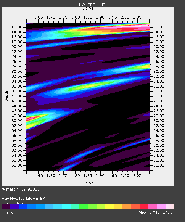
| Estimated Moho Depth: |
11.0 km |
| Estimated Crust Vp/Vs: |
2.10 |
| Assumed Crust Vp: |
6.571 km/s |
| Estimated Crust Vs: |
3.136 km/s |
| Estimated Crust Poisson's Ratio: |
0.35 |
|
| Radial Match: |
89.91036 % |
| Radial Bump: |
312 |
| Transverse Match: |
78.01095 % |
| Transverse Bump: |
400 |
| SOD ConfigId: |
21709731 |
| Insert Time: |
2020-07-07 15:51:57.320 +0000 |
| GWidth: |
2.5 |
| Max Bumps: |
400 |
| Tol: |
0.001 |
|

Signal To Noise
| Channel | StoN | STA | LTA |
| UW:IZEE: :HHZ:20200623T15:35:20.007988Z | 54.931133 | 1.0735321E-5 | 1.9543235E-7 |
| UW:IZEE: :HHN:20200623T15:35:20.007988Z | 14.716601 | 4.1582975E-6 | 2.825583E-7 |
| UW:IZEE: :HHE:20200623T15:35:20.007988Z | 12.9878645 | 3.6565355E-6 | 2.8153477E-7 |
| Arrivals |
| Ps | 2.0 SECOND |
| PpPs | 4.8 SECOND |
| PsPs/PpSs | 6.8 SECOND |


