You are here: Home > Network List > UW - Pacific Northwest Regional Seismic Network Stations List
> Station MANO Manastash Observatory, WA, USA > Earthquake Result Viewer
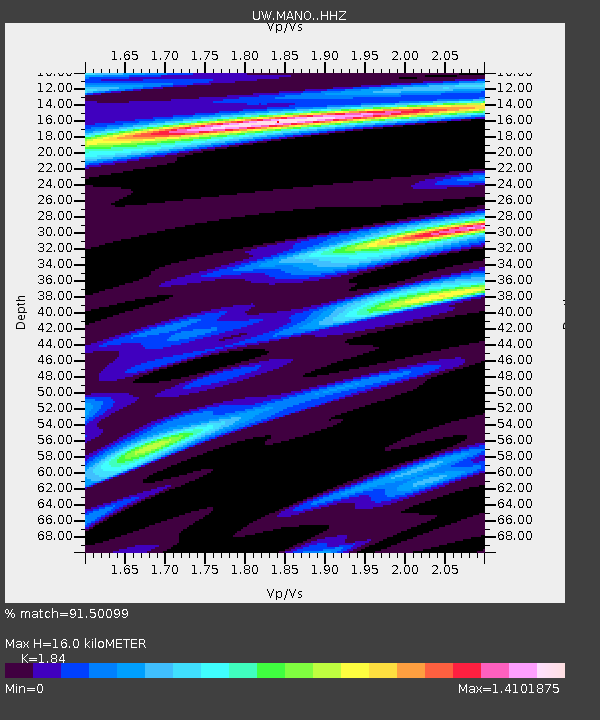
MANO Manastash Observatory, WA, USA - Earthquake Result Viewer
| Earthquake location: |
Near Coast Of Oaxaca, Mexico |
| Earthquake latitude/longitude: |
15.9/-95.9 |
| Earthquake time(UTC): |
2020/06/23 (175) 15:29:04 GMT |
| Earthquake Depth: |
20 km |
| Earthquake Magnitude: |
7.4 mww |
| Earthquake Catalog/Contributor: |
NEIC PDE/us |
|
| Network: |
UW Pacific Northwest Regional Seismic Network |
| Station: |
MANO Manastash Observatory, WA, USA |
| Lat/Lon: |
46.95 N/120.72 W |
| Elevation: |
1200 m |
|
| Distance: |
37.1 deg |
| Az: |
331.599 deg |
| Baz: |
138.09 deg |
| Ray Param: |
0.076287754 |
| Estimated Moho Depth: |
16.0 km |
| Estimated Crust Vp/Vs: |
1.84 |
| Assumed Crust Vp: |
6.597 km/s |
| Estimated Crust Vs: |
3.586 km/s |
| Estimated Crust Poisson's Ratio: |
0.29 |
|
| Radial Match: |
91.50099 % |
| Radial Bump: |
283 |
| Transverse Match: |
68.94336 % |
| Transverse Bump: |
400 |
| SOD ConfigId: |
21709731 |
| Insert Time: |
2020-07-07 15:52:13.674 +0000 |
| GWidth: |
2.5 |
| Max Bumps: |
400 |
| Tol: |
0.001 |
|

Signal To Noise
| Channel | StoN | STA | LTA |
| UW:MANO: :HHZ:20200623T15:35:43.089989Z | 75.5703 | 1.0893964E-5 | 1.4415669E-7 |
| UW:MANO: :HHN:20200623T15:35:43.089989Z | 15.974517 | 4.118535E-6 | 2.5781907E-7 |
| UW:MANO: :HHE:20200623T15:35:43.089989Z | 16.928741 | 3.6384276E-6 | 2.1492608E-7 |
| Arrivals |
| Ps | 2.2 SECOND |
| PpPs | 6.4 SECOND |
| PsPs/PpSs | 8.6 SECOND |


