You are here: Home > Network List > WI - West Indies IPGP Network Stations List
> Station MAGL Barre de l'ile, Marie-Galante, Guadeloupe > Earthquake Result Viewer
MAGL Barre de l'ile, Marie-Galante, Guadeloupe - Earthquake Result Viewer
| Earthquake location: |
Near Coast Of Oaxaca, Mexico |
| Earthquake latitude/longitude: |
15.9/-95.9 |
| Earthquake time(UTC): |
2020/06/23 (175) 15:29:04 GMT |
| Earthquake Depth: |
20 km |
| Earthquake Magnitude: |
7.4 mww |
| Earthquake Catalog/Contributor: |
NEIC PDE/us |
|
| Network: |
WI West Indies IPGP Network |
| Station: |
MAGL Barre de l'ile, Marie-Galante, Guadeloupe |
| Lat/Lon: |
15.95 N/61.28 W |
| Elevation: |
159 m |
|
| Distance: |
33.3 deg |
| Az: |
85.103 deg |
| Baz: |
274.838 deg |
| Ray Param: |
0.07826352 |
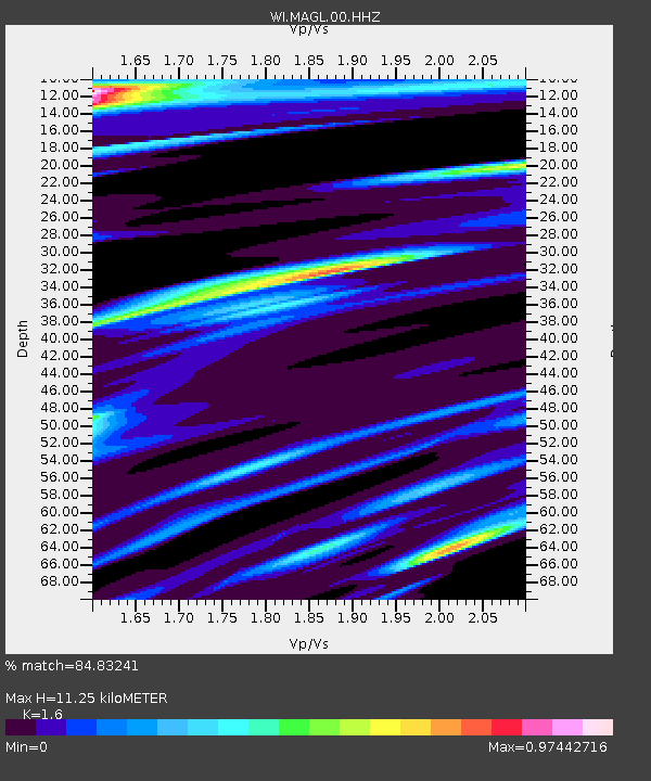
| Estimated Moho Depth: |
11.25 km |
| Estimated Crust Vp/Vs: |
1.60 |
| Assumed Crust Vp: |
5.88 km/s |
| Estimated Crust Vs: |
3.675 km/s |
| Estimated Crust Poisson's Ratio: |
0.18 |
|
| Radial Match: |
84.83241 % |
| Radial Bump: |
400 |
| Transverse Match: |
64.75965 % |
| Transverse Bump: |
400 |
| SOD ConfigId: |
21709731 |
| Insert Time: |
2020-07-07 15:53:04.078 +0000 |
| GWidth: |
2.5 |
| Max Bumps: |
400 |
| Tol: |
0.001 |
|
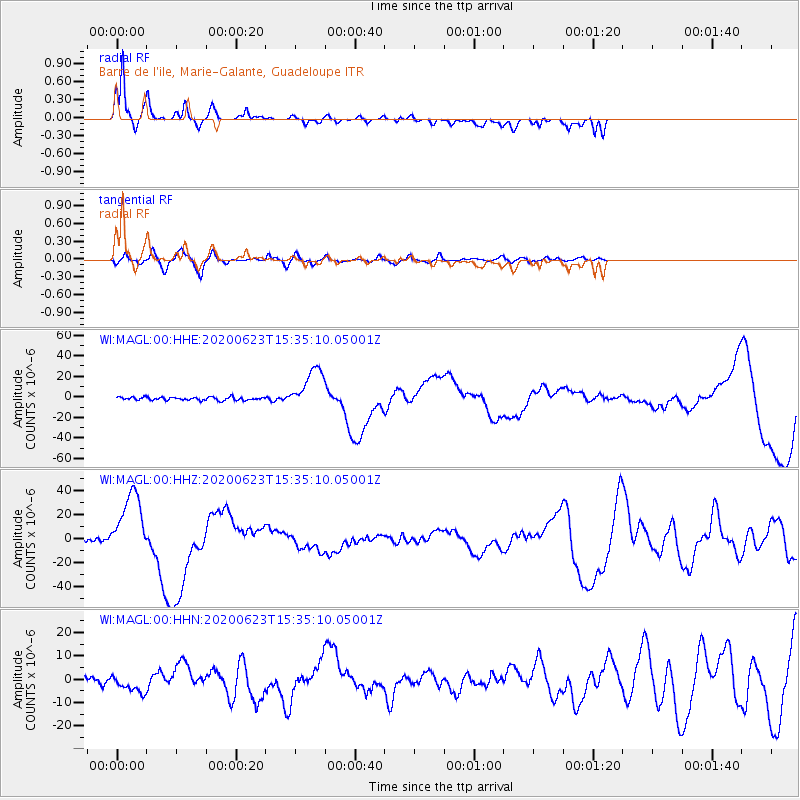
Signal To Noise
| Channel | StoN | STA | LTA |
| WI:MAGL:00:HHZ:20200623T15:35:10.05001Z | 20.961966 | 2.7858694E-5 | 1.3290115E-6 |
| WI:MAGL:00:HHN:20200623T15:35:10.05001Z | 2.1956623 | 3.6983572E-6 | 1.6843926E-6 |
| WI:MAGL:00:HHE:20200623T15:35:10.05001Z | 13.225917 | 2.0033285E-5 | 1.5146992E-6 |
| Arrivals |
| Ps | 1.2 SECOND |
| PpPs | 4.6 SECOND |
| PsPs/PpSs | 5.9 SECOND |


