You are here: Home > Network List > YO16 - Yukon Observatory Stations List
> Station LIRD YGS, Liard River Highway Maintenance Camp, BC > Earthquake Result Viewer
LIRD YGS, Liard River Highway Maintenance Camp, BC - Earthquake Result Viewer
| Earthquake location: |
Near Coast Of Oaxaca, Mexico |
| Earthquake latitude/longitude: |
15.9/-95.9 |
| Earthquake time(UTC): |
2020/06/23 (175) 15:29:04 GMT |
| Earthquake Depth: |
20 km |
| Earthquake Magnitude: |
7.4 mww |
| Earthquake Catalog/Contributor: |
NEIC PDE/us |
|
| Network: |
YO Yukon Observatory |
| Station: |
LIRD YGS, Liard River Highway Maintenance Camp, BC |
| Lat/Lon: |
59.41 N/126.10 W |
| Elevation: |
439 m |
|
| Distance: |
48.7 deg |
| Az: |
340.003 deg |
| Baz: |
139.961 deg |
| Ray Param: |
0.069159105 |
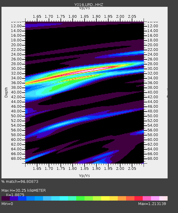
| Estimated Moho Depth: |
30.25 km |
| Estimated Crust Vp/Vs: |
1.89 |
| Assumed Crust Vp: |
6.419 km/s |
| Estimated Crust Vs: |
3.401 km/s |
| Estimated Crust Poisson's Ratio: |
0.30 |
|
| Radial Match: |
96.80873 % |
| Radial Bump: |
251 |
| Transverse Match: |
82.113594 % |
| Transverse Bump: |
400 |
| SOD ConfigId: |
21709731 |
| Insert Time: |
2020-07-07 15:54:03.978 +0000 |
| GWidth: |
2.5 |
| Max Bumps: |
400 |
| Tol: |
0.001 |
|

Signal To Noise
| Channel | StoN | STA | LTA |
| YO:LIRD: :HHZ:20200623T15:37:16.580009Z | 74.21882 | 1.2969271E-5 | 1.747437E-7 |
| YO:LIRD: :HHN:20200623T15:37:16.580009Z | 27.662039 | 5.8936184E-6 | 2.13058E-7 |
| YO:LIRD: :HHE:20200623T15:37:16.580009Z | 26.428535 | 4.486494E-6 | 1.6975947E-7 |
| Arrivals |
| Ps | 4.4 SECOND |
| PpPs | 13 SECOND |
| PsPs/PpSs | 17 SECOND |


