You are here: Home > Network List > KN - Kyrgyz Seismic Telemetry Network Stations List
> Station ULHL KN.ULHL > Earthquake Result Viewer
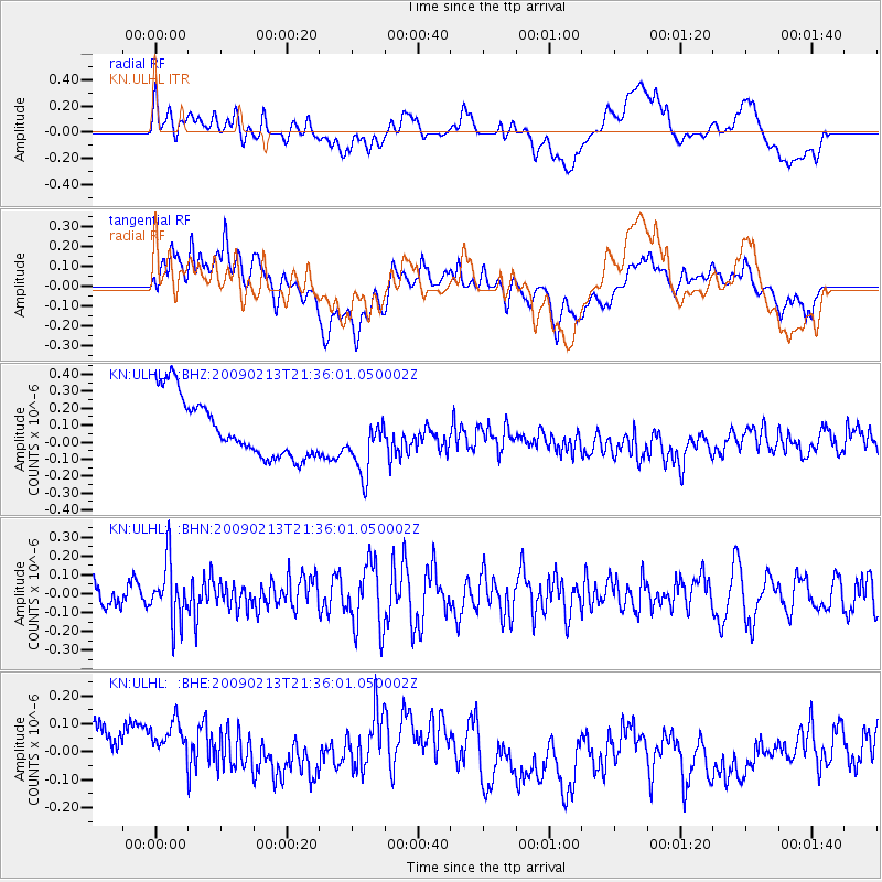
ULHL KN.ULHL - Earthquake Result Viewer
*The percent match for this event was below the threshold and hence no stack was calculated.
| Earthquake location: |
Talaud Islands, Indonesia |
| Earthquake latitude/longitude: |
3.8/126.5 |
| Earthquake time(UTC): |
2009/02/13 (044) 21:26:36 GMT |
| Earthquake Depth: |
32 km |
| Earthquake Magnitude: |
5.5 MB, 5.2 MW |
| Earthquake Catalog/Contributor: |
WHDF/NEIC |
|
| Network: |
KN Kyrgyz Seismic Telemetry Network |
| Station: |
ULHL KN.ULHL |
| Lat/Lon: |
42.25 N/76.24 E |
| Elevation: |
2040 m |
|
| Distance: |
58.8 deg |
| Az: |
318.16 deg |
| Baz: |
116.306 deg |
| Ray Param: |
$rayparam |
*The percent match for this event was below the threshold and hence was not used in the summary stack. |
|
| Radial Match: |
23.418959 % |
| Radial Bump: |
400 |
| Transverse Match: |
47.20901 % |
| Transverse Bump: |
400 |
| SOD ConfigId: |
2658 |
| Insert Time: |
2010-03-08 22:05:52.095 +0000 |
| GWidth: |
2.5 |
| Max Bumps: |
400 |
| Tol: |
0.001 |
|
Signal To Noise
| Channel | StoN | STA | LTA |
| KN:ULHL: :BHN:20090213T21:36:01.050002Z | 2.0367029 | 1.5462824E-7 | 7.592086E-8 |
| KN:ULHL: :BHE:20090213T21:36:01.050002Z | 1.1418552 | 1.9683138E-7 | 1.7237858E-7 |
| KN:ULHL: :BHZ:20090213T21:36:01.050002Z | 1.0367221 | 1.7929881E-7 | 1.7294781E-7 |
| Arrivals |
| Ps | |
| PpPs | |
| PsPs/PpSs | |


