You are here: Home > Network List > CN - Canadian National Seismograph Network Stations List
> Station INK INUVIK, NT > Earthquake Result Viewer
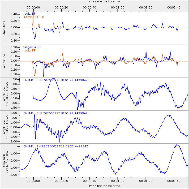
INK INUVIK, NT - Earthquake Result Viewer
*The percent match for this event was below the threshold and hence no stack was calculated.
| Earthquake location: |
Mariana Islands |
| Earthquake latitude/longitude: |
14.0/145.5 |
| Earthquake time(UTC): |
2020/06/23 (175) 17:50:26 GMT |
| Earthquake Depth: |
68 km |
| Earthquake Magnitude: |
5.9 mb |
| Earthquake Catalog/Contributor: |
NEIC PDE/us |
|
| Network: |
CN Canadian National Seismograph Network |
| Station: |
INK INUVIK, NT |
| Lat/Lon: |
68.31 N/133.53 W |
| Elevation: |
44 m |
|
| Distance: |
73.7 deg |
| Az: |
22.486 deg |
| Baz: |
266.864 deg |
| Ray Param: |
$rayparam |
*The percent match for this event was below the threshold and hence was not used in the summary stack. |
|
| Radial Match: |
58.61152 % |
| Radial Bump: |
353 |
| Transverse Match: |
61.52735 % |
| Transverse Bump: |
400 |
| SOD ConfigId: |
21709731 |
| Insert Time: |
2020-07-07 17:57:05.615 +0000 |
| GWidth: |
2.5 |
| Max Bumps: |
400 |
| Tol: |
0.001 |
|
Signal To Noise
| Channel | StoN | STA | LTA |
| CN:INK: :BHZ:20200623T18:01:22.449984Z | 2.0685067 | 1.376356E-6 | 6.6538627E-7 |
| CN:INK: :BHN:20200623T18:01:22.449984Z | 1.8993884 | 1.616783E-6 | 8.512124E-7 |
| CN:INK: :BHE:20200623T18:01:22.449984Z | 1.2862687 | 1.0481809E-6 | 8.1490043E-7 |
| Arrivals |
| Ps | |
| PpPs | |
| PsPs/PpSs | |


