You are here: Home > Network List > IU - Global Seismograph Network (GSN - IRIS/USGS) Stations List
> Station POHA Pohakuloa, Hawaii, USA > Earthquake Result Viewer
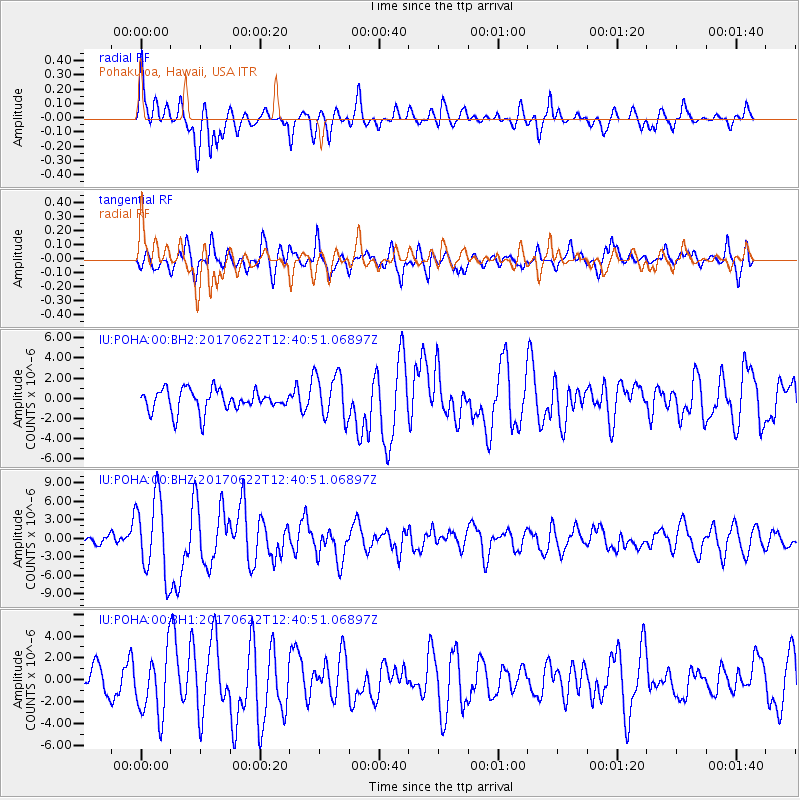
POHA Pohakuloa, Hawaii, USA - Earthquake Result Viewer
*The percent match for this event was below the threshold and hence no stack was calculated.
| Earthquake location: |
Near Coast Of Guatemala |
| Earthquake latitude/longitude: |
13.7/-91.1 |
| Earthquake time(UTC): |
2017/06/22 (173) 12:31:04 GMT |
| Earthquake Depth: |
10 km |
| Earthquake Magnitude: |
6.8 Mi |
| Earthquake Catalog/Contributor: |
NEIC PDE/at |
|
| Network: |
IU Global Seismograph Network (GSN - IRIS/USGS) |
| Station: |
POHA Pohakuloa, Hawaii, USA |
| Lat/Lon: |
19.76 N/155.53 W |
| Elevation: |
1990 m |
|
| Distance: |
61.7 deg |
| Az: |
285.206 deg |
| Baz: |
84.74 deg |
| Ray Param: |
$rayparam |
*The percent match for this event was below the threshold and hence was not used in the summary stack. |
|
| Radial Match: |
74.07449 % |
| Radial Bump: |
400 |
| Transverse Match: |
70.19114 % |
| Transverse Bump: |
400 |
| SOD ConfigId: |
2140511 |
| Insert Time: |
2017-07-06 04:23:56.997 +0000 |
| GWidth: |
2.5 |
| Max Bumps: |
400 |
| Tol: |
0.001 |
|
Signal To Noise
| Channel | StoN | STA | LTA |
| IU:POHA:00:BHZ:20170622T12:40:51.06897Z | 5.976013 | 6.4206147E-6 | 1.0743977E-6 |
| IU:POHA:00:BH1:20170622T12:40:51.06897Z | 1.8830796 | 2.9032165E-6 | 1.5417386E-6 |
| IU:POHA:00:BH2:20170622T12:40:51.06897Z | 2.139004 | 2.2859217E-6 | 1.0686852E-6 |
| Arrivals |
| Ps | |
| PpPs | |
| PsPs/PpSs | |


