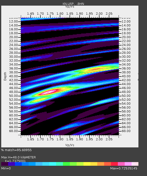
USP KN.USP - Earthquake Result Viewer
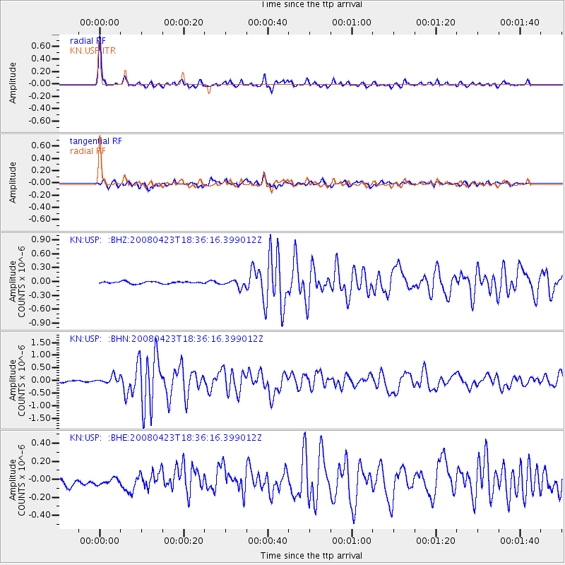
Earthquake location: Taiwan Region
Earthquake latitude/longitude: 22.9/121.6
Earthquake time(UTC): 2008/04/23 (114) 18:28:41 GMT
Earthquake Depth: 10 km
Earthquake Magnitude: 5.6 MB, 5.9 MS, 6.0 MW, 6.0 MW
Earthquake Catalog/Contributor: WHDF/NEIC
Network: KN Kyrgyz Seismic Telemetry Network
Station: USP KN.USP
Lat/Lon: 43.27 N/74.50 E
Elevation: 740 m
Distance: 43.7 deg
Az: 309.273 deg
Baz: 102.207 deg
Ray Param: 0.072354026
Estimated Moho Depth: 48.0 km
Estimated Crust Vp/Vs: 1.74
Assumed Crust Vp: 6.306 km/s
Estimated Crust Vs: 3.629 km/s
Estimated Crust Poisson's Ratio: 0.25
Radial Match: 95.68955 %
Radial Bump: 303
Transverse Match: 77.20655 %
Transverse Bump: 400
SOD ConfigId: 2504
Insert Time: 2010-03-08 22:06:11.948 +0000
GWidth: 2.5
Max Bumps: 400
Tol: 0.001

Signal To Noise

ChannelStoNSTALTA
KN:USP: :BHN:20080423T18:36:16.399012Z2.40870551.470827E-76.106296E-8
KN:USP: :BHE:20080423T18:36:16.399012Z0.96361723.97204E-84.12201E-8
KN:USP: :BHZ:20080423T18:36:16.399012Z3.69653258.068234E-82.1826493E-8
Arrivals
Ps6.0 SECOND
PpPs20 SECOND
PsPs/PpSs26 SECOND