You are here: Home > Network List > TA - USArray Transportable Network (new EarthScope stations) Stations List
> Station G16K Koyuk River, AK, USA > Earthquake Result Viewer
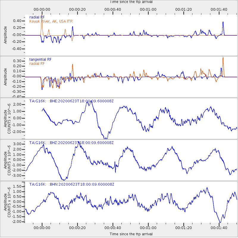
G16K Koyuk River, AK, USA - Earthquake Result Viewer
*The percent match for this event was below the threshold and hence no stack was calculated.
| Earthquake location: |
Mariana Islands |
| Earthquake latitude/longitude: |
14.0/145.5 |
| Earthquake time(UTC): |
2020/06/23 (175) 17:50:26 GMT |
| Earthquake Depth: |
68 km |
| Earthquake Magnitude: |
5.9 mb |
| Earthquake Catalog/Contributor: |
NEIC PDE/us |
|
| Network: |
TA USArray Transportable Network (new EarthScope stations) |
| Station: |
G16K Koyuk River, AK, USA |
| Lat/Lon: |
65.39 N/162.35 W |
| Elevation: |
169 m |
|
| Distance: |
62.1 deg |
| Az: |
21.956 deg |
| Baz: |
240.088 deg |
| Ray Param: |
$rayparam |
*The percent match for this event was below the threshold and hence was not used in the summary stack. |
|
| Radial Match: |
89.73943 % |
| Radial Bump: |
400 |
| Transverse Match: |
66.94033 % |
| Transverse Bump: |
400 |
| SOD ConfigId: |
21709731 |
| Insert Time: |
2020-07-07 18:01:44.919 +0000 |
| GWidth: |
2.5 |
| Max Bumps: |
400 |
| Tol: |
0.001 |
|
Signal To Noise
| Channel | StoN | STA | LTA |
| TA:G16K: :BHZ:20200623T18:00:09.600008Z | 2.1208165 | 2.544493E-6 | 1.1997705E-6 |
| TA:G16K: :BHN:20200623T18:00:09.600008Z | 0.8818552 | 4.6954386E-7 | 5.3245003E-7 |
| TA:G16K: :BHE:20200623T18:00:09.600008Z | 2.2523696 | 1.5255284E-6 | 6.772993E-7 |
| Arrivals |
| Ps | |
| PpPs | |
| PsPs/PpSs | |


