You are here: Home > Network List > AK - Alaska Regional Network Stations List
> Station M19K Big River Lodge, Big River, AK, USA > Earthquake Result Viewer
M19K Big River Lodge, Big River, AK, USA - Earthquake Result Viewer
| Earthquake location: |
California-Nevada Border Region |
| Earthquake latitude/longitude: |
36.5/-118.0 |
| Earthquake time(UTC): |
2020/06/24 (176) 17:40:49 GMT |
| Earthquake Depth: |
2.9 km |
| Earthquake Magnitude: |
6.0 me |
| Earthquake Catalog/Contributor: |
NEIC PDE/ci |
|
| Network: |
AK Alaska Regional Network |
| Station: |
M19K Big River Lodge, Big River, AK, USA |
| Lat/Lon: |
61.90 N/154.39 W |
| Elevation: |
521 m |
|
| Distance: |
34.1 deg |
| Az: |
329.896 deg |
| Baz: |
121.331 deg |
| Ray Param: |
0.07793598 |
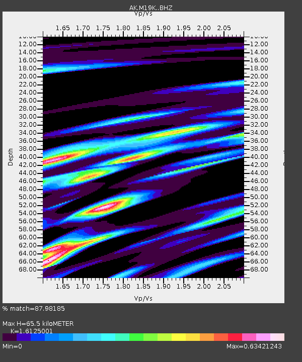
| Estimated Moho Depth: |
65.5 km |
| Estimated Crust Vp/Vs: |
1.61 |
| Assumed Crust Vp: |
6.566 km/s |
| Estimated Crust Vs: |
4.072 km/s |
| Estimated Crust Poisson's Ratio: |
0.19 |
|
| Radial Match: |
87.98185 % |
| Radial Bump: |
266 |
| Transverse Match: |
55.44583 % |
| Transverse Bump: |
400 |
| SOD ConfigId: |
21709731 |
| Insert Time: |
2020-07-08 17:42:24.812 +0000 |
| GWidth: |
2.5 |
| Max Bumps: |
400 |
| Tol: |
0.001 |
|

Signal To Noise
| Channel | StoN | STA | LTA |
| AK:M19K: :BHZ:20200624T17:47:04.020015Z | 2.7457075 | 2.9150442E-7 | 1.0616732E-7 |
| AK:M19K: :BHN:20200624T17:47:04.020015Z | 1.2720509 | 6.820412E-8 | 5.3617452E-8 |
| AK:M19K: :BHE:20200624T17:47:04.020015Z | 1.8379154 | 1.5537087E-7 | 8.453647E-8 |
| Arrivals |
| Ps | 6.7 SECOND |
| PpPs | 24 SECOND |
| PsPs/PpSs | 31 SECOND |


