You are here: Home > Network List > AV - Alaska Volcano Observatory Stations List
> Station AMKA Regional Station, Amchitka Island, Alaska > Earthquake Result Viewer
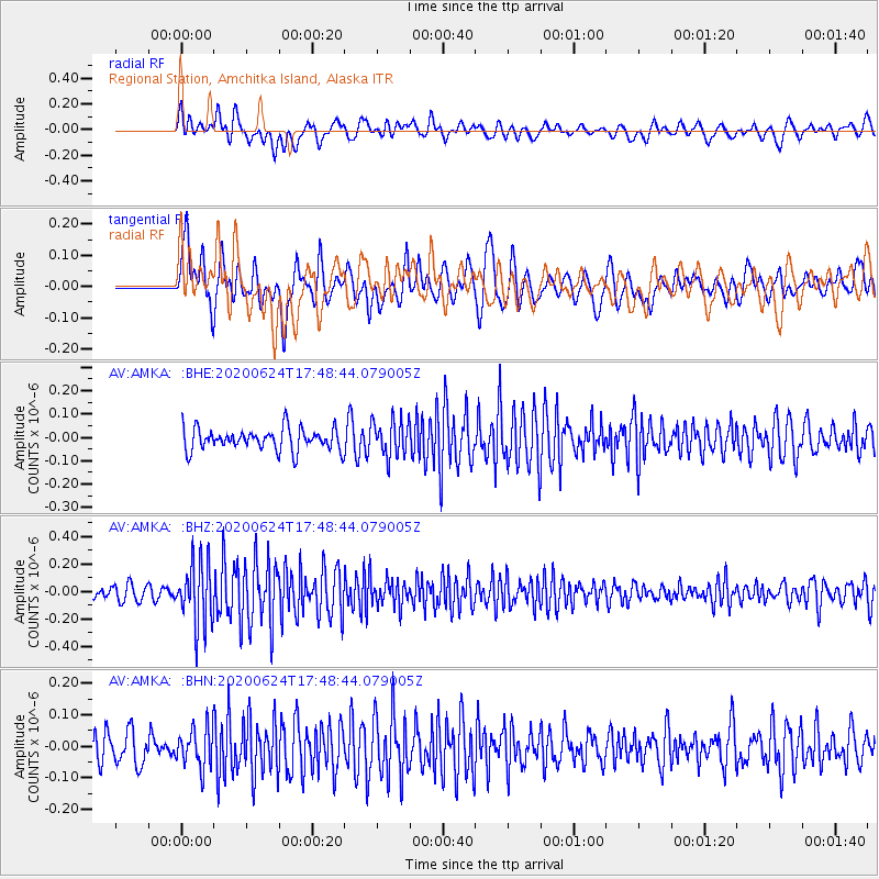
AMKA Regional Station, Amchitka Island, Alaska - Earthquake Result Viewer
*The percent match for this event was below the threshold and hence no stack was calculated.
| Earthquake location: |
California-Nevada Border Region |
| Earthquake latitude/longitude: |
36.5/-118.0 |
| Earthquake time(UTC): |
2020/06/24 (176) 17:40:49 GMT |
| Earthquake Depth: |
2.9 km |
| Earthquake Magnitude: |
6.0 me |
| Earthquake Catalog/Contributor: |
NEIC PDE/ci |
|
| Network: |
AV Alaska Volcano Observatory |
| Station: |
AMKA Regional Station, Amchitka Island, Alaska |
| Lat/Lon: |
51.38 N/179.30 E |
| Elevation: |
116 m |
|
| Distance: |
46.2 deg |
| Az: |
309.448 deg |
| Baz: |
83.403 deg |
| Ray Param: |
$rayparam |
*The percent match for this event was below the threshold and hence was not used in the summary stack. |
|
| Radial Match: |
61.38484 % |
| Radial Bump: |
400 |
| Transverse Match: |
58.050278 % |
| Transverse Bump: |
400 |
| SOD ConfigId: |
21709731 |
| Insert Time: |
2020-07-08 17:43:34.428 +0000 |
| GWidth: |
2.5 |
| Max Bumps: |
400 |
| Tol: |
0.001 |
|
Signal To Noise
| Channel | StoN | STA | LTA |
| AV:AMKA: :BHZ:20200624T17:48:44.079005Z | 4.893936 | 2.2926709E-7 | 4.6847173E-8 |
| AV:AMKA: :BHN:20200624T17:48:44.079005Z | 1.4046217 | 6.295106E-8 | 4.4817092E-8 |
| AV:AMKA: :BHE:20200624T17:48:44.079005Z | 1.6477389 | 7.757716E-8 | 4.7080977E-8 |
| Arrivals |
| Ps | |
| PpPs | |
| PsPs/PpSs | |


