You are here: Home > Network List > AV - Alaska Volcano Observatory Stations List
> Station ILSW Iliamna Southwest, Iliamna Volcano, Alaska > Earthquake Result Viewer
ILSW Iliamna Southwest, Iliamna Volcano, Alaska - Earthquake Result Viewer
| Earthquake location: |
California-Nevada Border Region |
| Earthquake latitude/longitude: |
36.5/-118.0 |
| Earthquake time(UTC): |
2020/06/24 (176) 17:40:49 GMT |
| Earthquake Depth: |
2.9 km |
| Earthquake Magnitude: |
6.0 me |
| Earthquake Catalog/Contributor: |
NEIC PDE/ci |
|
| Network: |
AV Alaska Volcano Observatory |
| Station: |
ILSW Iliamna Southwest, Iliamna Volcano, Alaska |
| Lat/Lon: |
59.98 N/153.14 W |
| Elevation: |
1318 m |
|
| Distance: |
32.6 deg |
| Az: |
327.454 deg |
| Baz: |
120.38 deg |
| Ray Param: |
0.07862112 |
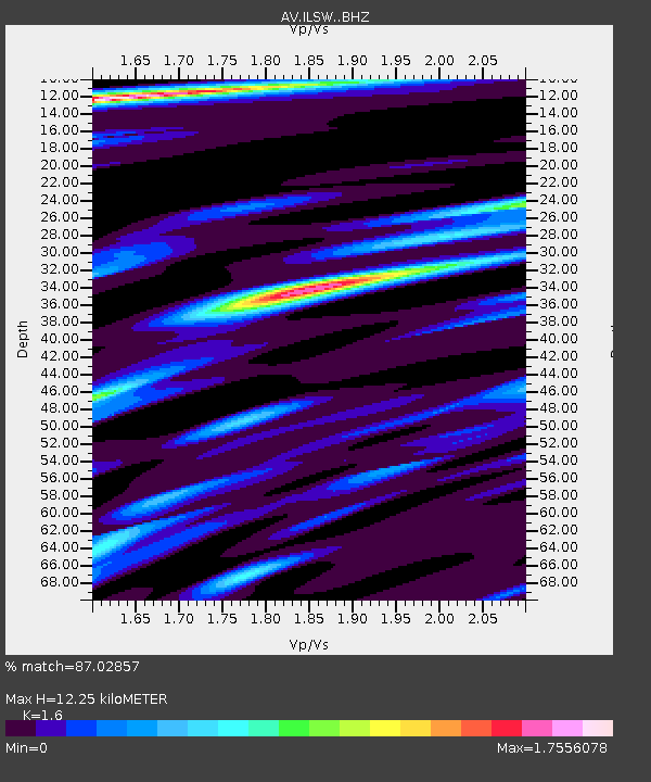
| Estimated Moho Depth: |
12.25 km |
| Estimated Crust Vp/Vs: |
1.60 |
| Assumed Crust Vp: |
5.989 km/s |
| Estimated Crust Vs: |
3.743 km/s |
| Estimated Crust Poisson's Ratio: |
0.18 |
|
| Radial Match: |
87.02857 % |
| Radial Bump: |
400 |
| Transverse Match: |
76.69418 % |
| Transverse Bump: |
400 |
| SOD ConfigId: |
21709731 |
| Insert Time: |
2020-07-08 17:44:09.816 +0000 |
| GWidth: |
2.5 |
| Max Bumps: |
400 |
| Tol: |
0.001 |
|
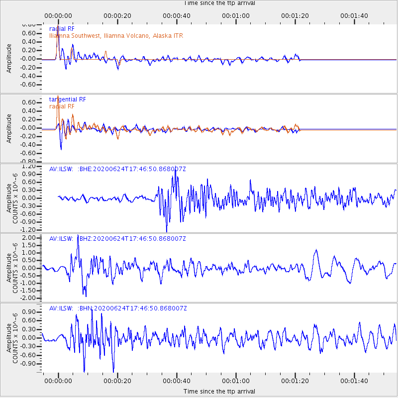
Signal To Noise
| Channel | StoN | STA | LTA |
| AV:ILSW: :BHZ:20200624T17:46:50.868007Z | 3.7378988 | 3.4524345E-7 | 9.2362974E-8 |
| AV:ILSW: :BHN:20200624T17:46:50.868007Z | 1.8860168 | 1.9879154E-7 | 1.0540284E-7 |
| AV:ILSW: :BHE:20200624T17:46:50.868007Z | 2.7880502 | 1.8066797E-7 | 6.480083E-8 |
| Arrivals |
| Ps | 1.3 SECOND |
| PpPs | 4.9 SECOND |
| PsPs/PpSs | 6.3 SECOND |


