You are here: Home > Network List > AV - Alaska Volcano Observatory Stations List
> Station PLBL Mt. Peulik Volcano, Alaska > Earthquake Result Viewer
PLBL Mt. Peulik Volcano, Alaska - Earthquake Result Viewer
*The percent match for this event was below the threshold and hence no stack was calculated.
| Earthquake location: |
California-Nevada Border Region |
| Earthquake latitude/longitude: |
36.5/-118.0 |
| Earthquake time(UTC): |
2020/06/24 (176) 17:40:49 GMT |
| Earthquake Depth: |
2.9 km |
| Earthquake Magnitude: |
6.0 me |
| Earthquake Catalog/Contributor: |
NEIC PDE/ci |
|
| Network: |
AV Alaska Volcano Observatory |
| Station: |
PLBL Mt. Peulik Volcano, Alaska |
| Lat/Lon: |
57.70 N/156.82 W |
| Elevation: |
461 m |
|
| Distance: |
33.3 deg |
| Az: |
322.109 deg |
| Baz: |
112.749 deg |
| Ray Param: |
$rayparam |
*The percent match for this event was below the threshold and hence was not used in the summary stack. |
|
| Radial Match: |
74.248695 % |
| Radial Bump: |
400 |
| Transverse Match: |
61.991108 % |
| Transverse Bump: |
400 |
| SOD ConfigId: |
21709731 |
| Insert Time: |
2020-07-08 17:44:40.318 +0000 |
| GWidth: |
2.5 |
| Max Bumps: |
400 |
| Tol: |
0.001 |
|
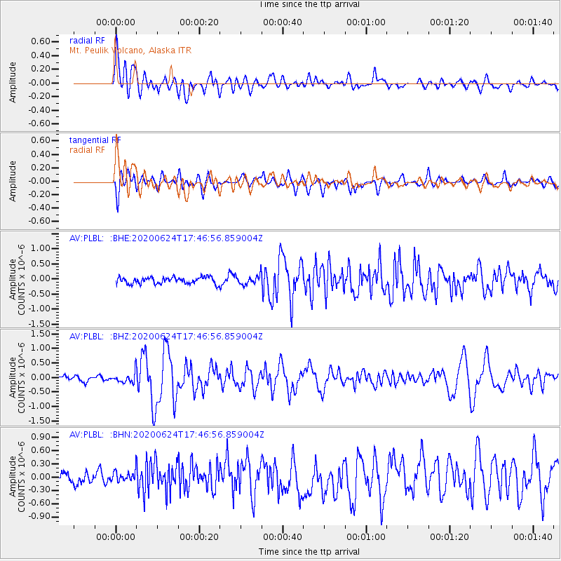
Signal To Noise
| Channel | StoN | STA | LTA |
| AV:PLBL: :BHZ:20200624T17:46:56.859004Z | 2.0230222 | 1.9058938E-7 | 9.421022E-8 |
| AV:PLBL: :BHN:20200624T17:46:56.859004Z | 1.0429987 | 1.5612584E-7 | 1.4968938E-7 |
| AV:PLBL: :BHE:20200624T17:46:56.859004Z | 1.4383043 | 1.5911083E-7 | 1.10623894E-7 |
| Arrivals |
| Ps | |
| PpPs | |
| PsPs/PpSs | |


