You are here: Home > Network List > AV - Alaska Volcano Observatory Stations List
> Station SPCR Ckakachatna River, Mount Spurr, Alaska > Earthquake Result Viewer
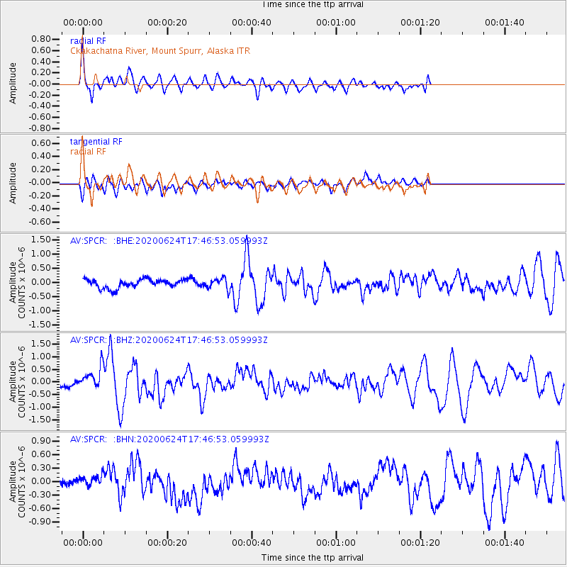
SPCR Ckakachatna River, Mount Spurr, Alaska - Earthquake Result Viewer
*The percent match for this event was below the threshold and hence no stack was calculated.
| Earthquake location: |
California-Nevada Border Region |
| Earthquake latitude/longitude: |
36.5/-118.0 |
| Earthquake time(UTC): |
2020/06/24 (176) 17:40:49 GMT |
| Earthquake Depth: |
2.9 km |
| Earthquake Magnitude: |
6.0 me |
| Earthquake Catalog/Contributor: |
NEIC PDE/ci |
|
| Network: |
AV Alaska Volcano Observatory |
| Station: |
SPCR Ckakachatna River, Mount Spurr, Alaska |
| Lat/Lon: |
61.20 N/152.21 W |
| Elevation: |
984 m |
|
| Distance: |
32.8 deg |
| Az: |
329.825 deg |
| Baz: |
123.188 deg |
| Ray Param: |
$rayparam |
*The percent match for this event was below the threshold and hence was not used in the summary stack. |
|
| Radial Match: |
75.749596 % |
| Radial Bump: |
400 |
| Transverse Match: |
61.230373 % |
| Transverse Bump: |
400 |
| SOD ConfigId: |
21709731 |
| Insert Time: |
2020-07-08 17:44:57.125 +0000 |
| GWidth: |
2.5 |
| Max Bumps: |
400 |
| Tol: |
0.001 |
|
Signal To Noise
| Channel | StoN | STA | LTA |
| AV:SPCR: :BHZ:20200624T17:46:53.059993Z | 2.4090073 | 4.4898468E-7 | 1.8637746E-7 |
| AV:SPCR: :BHN:20200624T17:46:53.059993Z | 0.61856306 | 1.3400414E-7 | 2.1663779E-7 |
| AV:SPCR: :BHE:20200624T17:46:53.059993Z | 1.2460836 | 1.8856863E-7 | 1.5132905E-7 |
| Arrivals |
| Ps | |
| PpPs | |
| PsPs/PpSs | |


