You are here: Home > Network List > G - GEOSCOPE Stations List
> Station MPG Montagne des Peres, French Guyana > Earthquake Result Viewer
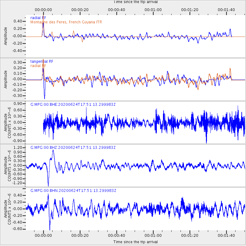
MPG Montagne des Peres, French Guyana - Earthquake Result Viewer
*The percent match for this event was below the threshold and hence no stack was calculated.
| Earthquake location: |
California-Nevada Border Region |
| Earthquake latitude/longitude: |
36.5/-118.0 |
| Earthquake time(UTC): |
2020/06/24 (176) 17:40:49 GMT |
| Earthquake Depth: |
2.9 km |
| Earthquake Magnitude: |
6.0 me |
| Earthquake Catalog/Contributor: |
NEIC PDE/ci |
|
| Network: |
G GEOSCOPE |
| Station: |
MPG Montagne des Peres, French Guyana |
| Lat/Lon: |
5.11 N/52.64 W |
| Elevation: |
147 m |
|
| Distance: |
67.2 deg |
| Az: |
100.921 deg |
| Baz: |
307.367 deg |
| Ray Param: |
$rayparam |
*The percent match for this event was below the threshold and hence was not used in the summary stack. |
|
| Radial Match: |
54.695374 % |
| Radial Bump: |
400 |
| Transverse Match: |
56.087353 % |
| Transverse Bump: |
400 |
| SOD ConfigId: |
21709731 |
| Insert Time: |
2020-07-08 17:48:57.724 +0000 |
| GWidth: |
2.5 |
| Max Bumps: |
400 |
| Tol: |
0.001 |
|
Signal To Noise
| Channel | StoN | STA | LTA |
| G:MPG:00:BHZ:20200624T17:51:13.299983Z | 3.0296366 | 4.945925E-7 | 1.6325141E-7 |
| G:MPG:00:BHN:20200624T17:51:13.299983Z | 1.8181654 | 2.2510692E-7 | 1.2380993E-7 |
| G:MPG:00:BHE:20200624T17:51:13.299983Z | 1.155484 | 2.1828615E-7 | 1.8891318E-7 |
| Arrivals |
| Ps | |
| PpPs | |
| PsPs/PpSs | |


