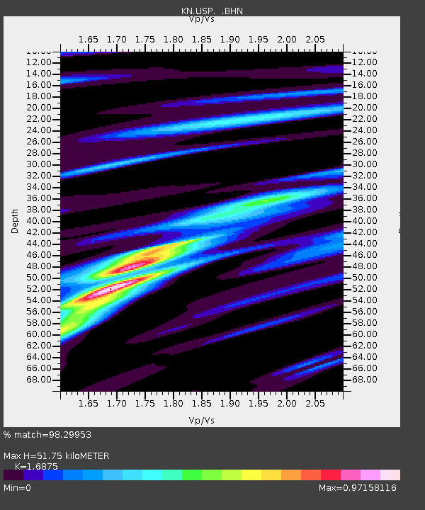
USP KN.USP - Earthquake Result Viewer
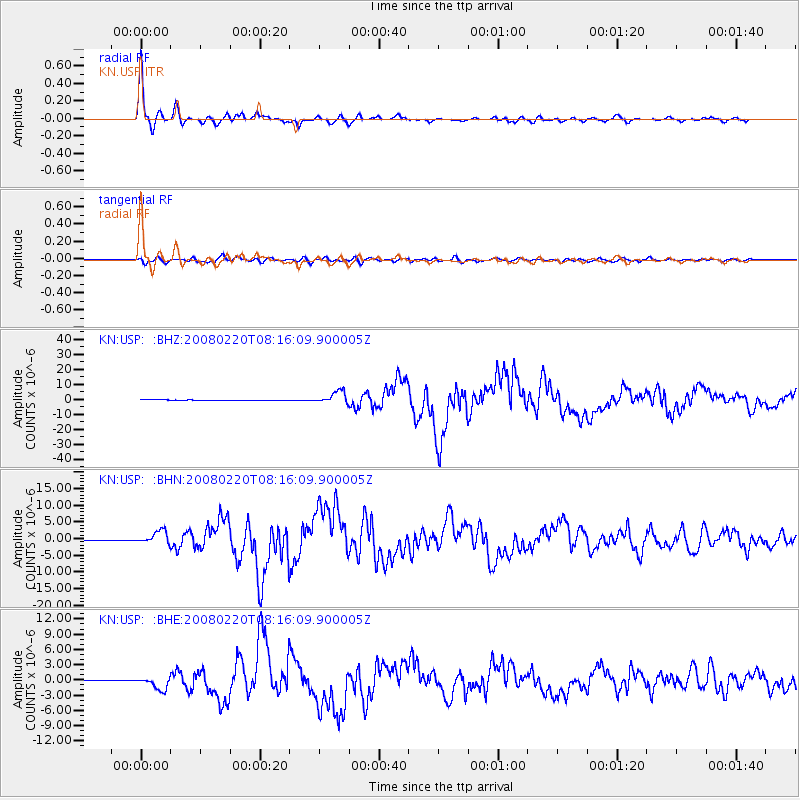
Earthquake location: Off W Coast Of Northern Sumatra
Earthquake latitude/longitude: 2.8/96.0
Earthquake time(UTC): 2008/02/20 (051) 08:08:30 GMT
Earthquake Depth: 26 km
Earthquake Magnitude: 6.5 MB, 7.5 MS, 7.4 MW, 7.4 MW
Earthquake Catalog/Contributor: WHDF/NEIC
Network: KN Kyrgyz Seismic Telemetry Network
Station: USP KN.USP
Lat/Lon: 43.27 N/74.50 E
Elevation: 740 m
Distance: 44.6 deg
Az: 337.633 deg
Baz: 148.644 deg
Ray Param: 0.07176133
Estimated Moho Depth: 51.75 km
Estimated Crust Vp/Vs: 1.69
Assumed Crust Vp: 6.306 km/s
Estimated Crust Vs: 3.737 km/s
Estimated Crust Poisson's Ratio: 0.23
Radial Match: 98.29953 %
Radial Bump: 294
Transverse Match: 86.93883 %
Transverse Bump: 400
SOD ConfigId: 2564
Insert Time: 2010-03-08 22:08:02.904 +0000
GWidth: 2.5
Max Bumps: 400
Tol: 0.001

Signal To Noise

ChannelStoNSTALTA
KN:USP: :BHN:20080220T08:16:09.900005Z16.3202271.9055208E-61.1675824E-7
KN:USP: :BHE:20080220T08:16:09.900005Z18.5951941.2425113E-66.6818956E-8
KN:USP: :BHZ:20080220T08:16:09.900005Z38.8642464.0658674E-61.0461717E-7
Arrivals
Ps6.0 SECOND
PpPs21 SECOND
PsPs/PpSs27 SECOND