You are here: Home > Network List > TA - USArray Transportable Network (new EarthScope stations) Stations List
> Station POKR Poker Plat Research Range, AK, USA > Earthquake Result Viewer
POKR Poker Plat Research Range, AK, USA - Earthquake Result Viewer

| Earthquake location: |
Near Coast Of Guatemala |
| Earthquake latitude/longitude: |
13.7/-91.1 |
| Earthquake time(UTC): |
2017/06/22 (173) 12:31:04 GMT |
| Earthquake Depth: |
10 km |
| Earthquake Magnitude: |
6.8 Mi |
| Earthquake Catalog/Contributor: |
NEIC PDE/at |
|
| Network: |
TA USArray Transportable Network (new EarthScope stations) |
| Station: |
POKR Poker Plat Research Range, AK, USA |
| Lat/Lon: |
65.12 N/147.43 W |
| Elevation: |
501 m |
|
| Distance: |
63.8 deg |
| Az: |
336.897 deg |
| Baz: |
115.661 deg |
| Ray Param: |
0.059327904 |
| Estimated Moho Depth: |
36.5 km |
| Estimated Crust Vp/Vs: |
1.65 |
| Assumed Crust Vp: |
6.566 km/s |
| Estimated Crust Vs: |
3.986 km/s |
| Estimated Crust Poisson's Ratio: |
0.21 |
|
| Radial Match: |
96.2861 % |
| Radial Bump: |
400 |
| Transverse Match: |
82.46372 % |
| Transverse Bump: |
400 |
| SOD ConfigId: |
2140511 |
| Insert Time: |
2017-07-06 04:25:21.836 +0000 |
| GWidth: |
2.5 |
| Max Bumps: |
400 |
| Tol: |
0.001 |
|
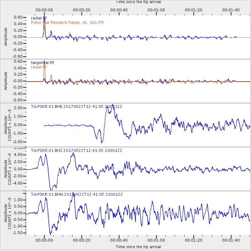
Signal To Noise
| Channel | StoN | STA | LTA |
| TA:POKR:01:BHZ:20170622T12:41:05.200012Z | 44.06746 | 3.7945724E-6 | 8.6108265E-8 |
| TA:POKR:01:BHN:20170622T12:41:05.200012Z | 17.919233 | 9.5017754E-7 | 5.302557E-8 |
| TA:POKR:01:BHE:20170622T12:41:05.200012Z | 34.34591 | 1.4551958E-6 | 4.2368825E-8 |
| Arrivals |
| Ps | 3.8 SECOND |
| PpPs | 14 SECOND |
| PsPs/PpSs | 18 SECOND |


