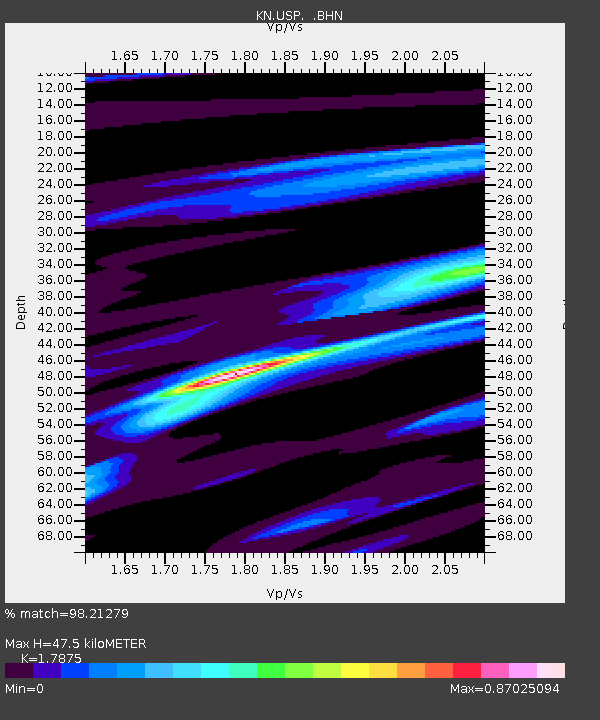
USP KN.USP - Earthquake Result Viewer

Earthquake location: Irian Jaya Region, Indonesia
Earthquake latitude/longitude: -0.4/132.9
Earthquake time(UTC): 2009/01/03 (003) 19:43:50 GMT
Earthquake Depth: 17 km
Earthquake Magnitude: 6.6 MB, 7.5 MS, 7.6 MW, 7.6 MW
Earthquake Catalog/Contributor: WHDF/NEIC
Network: KN Kyrgyz Seismic Telemetry Network
Station: USP KN.USP
Lat/Lon: 43.27 N/74.50 E
Elevation: 740 m
Distance: 67.8 deg
Az: 317.786 deg
Baz: 113.101 deg
Ray Param: 0.056712527
Estimated Moho Depth: 47.5 km
Estimated Crust Vp/Vs: 1.79
Assumed Crust Vp: 6.306 km/s
Estimated Crust Vs: 3.528 km/s
Estimated Crust Poisson's Ratio: 0.27
Radial Match: 98.21279 %
Radial Bump: 386
Transverse Match: 95.74215 %
Transverse Bump: 400
SOD ConfigId: 2834
Insert Time: 2010-03-08 22:08:12.488 +0000
GWidth: 2.5
Max Bumps: 400
Tol: 0.001

Signal To Noise

ChannelStoNSTALTA
KN:USP: :BHN:20090103T19:54:16.300024Z6.58901456.311842E-79.579342E-8
KN:USP: :BHE:20090103T19:54:16.300024Z1.77924591.2880693E-77.2394116E-8
KN:USP: :BHZ:20090103T19:54:16.300024Z0.908829152.0135525E-72.2155457E-7
Arrivals
Ps6.2 SECOND
PpPs20 SECOND
PsPs/PpSs26 SECOND