You are here: Home > Network List > KN - Kyrgyz Seismic Telemetry Network Stations List
> Station USP KN.USP > Earthquake Result Viewer
USP KN.USP - Earthquake Result Viewer
| Earthquake location: |
Off East Coast Of Honshu, Japan |
| Earthquake latitude/longitude: |
39.4/143.4 |
| Earthquake time(UTC): |
1992/07/18 (200) 08:36:59 GMT |
| Earthquake Depth: |
33 km |
| Earthquake Magnitude: |
6.1 MB, 6.9 MS |
| Earthquake Catalog/Contributor: |
WHDF/NEIC |
|
| Network: |
KN Kyrgyz Seismic Telemetry Network |
| Station: |
USP KN.USP |
| Lat/Lon: |
43.27 N/74.50 E |
| Elevation: |
740 m |
|
| Distance: |
50.5 deg |
| Az: |
298.058 deg |
| Baz: |
69.485 deg |
| Ray Param: |
0.06791967 |
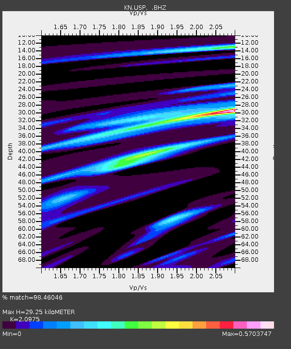
| Estimated Moho Depth: |
29.25 km |
| Estimated Crust Vp/Vs: |
2.10 |
| Assumed Crust Vp: |
6.306 km/s |
| Estimated Crust Vs: |
3.006 km/s |
| Estimated Crust Poisson's Ratio: |
0.35 |
|
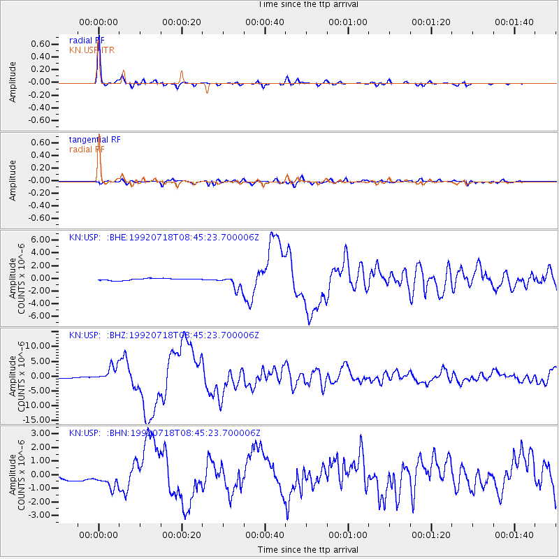
| Radial Match: |
98.46046 % |
| Radial Bump: |
268 |
| Transverse Match: |
90.68832 % |
| Transverse Bump: |
400 |
| SOD ConfigId: |
4480 |
| Insert Time: |
2010-03-08 22:08:19.532 +0000 |
| GWidth: |
2.5 |
| Max Bumps: |
400 |
| Tol: |
0.001 |
|
Signal To Noise
| Channel | StoN | STA | LTA |
| KN:USP: :BHZ:19920718T08:45:23.700006Z | 11.628778 | 2.758434E-6 | 2.3720754E-7 |
| KN:USP: :BHN:19920718T08:45:23.700006Z | 2.4864058 | 7.2183457E-7 | 2.9031244E-7 |
| KN:USP: :BHE:19920718T08:45:23.700006Z | 7.5686927 | 1.1485726E-6 | 1.517531E-7 |
| Arrivals |
| Ps | 5.3 SECOND |
| PpPs | 14 SECOND |
| PsPs/PpSs | 19 SECOND |


