You are here: Home > Network List > NE - New England Seismic Network Stations List
> Station EMMW Machias, ME, USA > Earthquake Result Viewer
EMMW Machias, ME, USA - Earthquake Result Viewer
*The percent match for this event was below the threshold and hence no stack was calculated.
| Earthquake location: |
California-Nevada Border Region |
| Earthquake latitude/longitude: |
36.5/-118.0 |
| Earthquake time(UTC): |
2020/06/24 (176) 17:40:49 GMT |
| Earthquake Depth: |
2.9 km |
| Earthquake Magnitude: |
6.0 me |
| Earthquake Catalog/Contributor: |
NEIC PDE/ci |
|
| Network: |
NE New England Seismic Network |
| Station: |
EMMW Machias, ME, USA |
| Lat/Lon: |
44.71 N/67.46 W |
| Elevation: |
35 m |
|
| Distance: |
38.7 deg |
| Az: |
61.644 deg |
| Baz: |
275.725 deg |
| Ray Param: |
$rayparam |
*The percent match for this event was below the threshold and hence was not used in the summary stack. |
|
| Radial Match: |
77.84781 % |
| Radial Bump: |
400 |
| Transverse Match: |
52.774384 % |
| Transverse Bump: |
400 |
| SOD ConfigId: |
21709731 |
| Insert Time: |
2020-07-08 17:52:47.159 +0000 |
| GWidth: |
2.5 |
| Max Bumps: |
400 |
| Tol: |
0.001 |
|
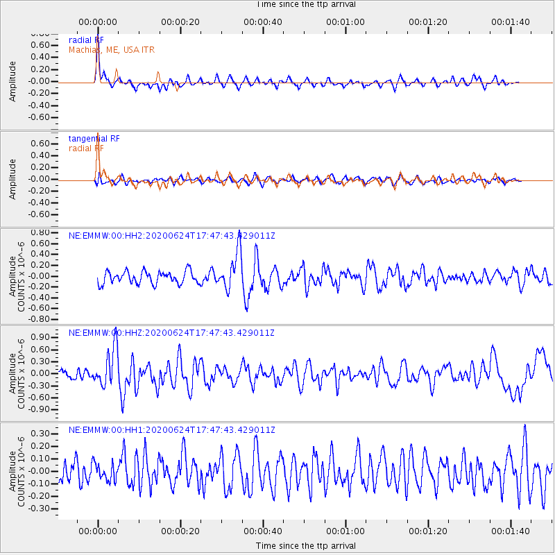
Signal To Noise
| Channel | StoN | STA | LTA |
| NE:EMMW:00:HHZ:20200624T17:47:43.429011Z | 4.7454696 | 5.089983E-7 | 1.0725984E-7 |
| NE:EMMW:00:HH1:20200624T17:47:43.429011Z | 0.5973794 | 6.3526045E-8 | 1.063412E-7 |
| NE:EMMW:00:HH2:20200624T17:47:43.429011Z | 3.1644197 | 3.601944E-7 | 1.13826374E-7 |
| Arrivals |
| Ps | |
| PpPs | |
| PsPs/PpSs | |


