You are here: Home > Network List > PR - Puerto Rico Seismic Network (PRSN) & Puerto Rico Strong Motion Program (PRSMP) Stations List
> Station MLPR PRSN > Earthquake Result Viewer
MLPR PRSN - Earthquake Result Viewer
| Earthquake location: |
California-Nevada Border Region |
| Earthquake latitude/longitude: |
36.5/-118.0 |
| Earthquake time(UTC): |
2020/06/24 (176) 17:40:49 GMT |
| Earthquake Depth: |
2.9 km |
| Earthquake Magnitude: |
6.0 me |
| Earthquake Catalog/Contributor: |
NEIC PDE/ci |
|
| Network: |
PR Puerto Rico Seismic Network (PRSN) & Puerto Rico Strong Motion Program (PRSMP) |
| Station: |
MLPR PRSN |
| Lat/Lon: |
17.97 N/67.04 W |
| Elevation: |
31 m |
|
| Distance: |
48.3 deg |
| Az: |
98.292 deg |
| Baz: |
303.05 deg |
| Ray Param: |
0.069467716 |
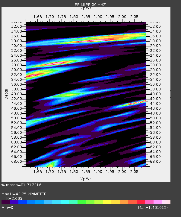
| Estimated Moho Depth: |
43.25 km |
| Estimated Crust Vp/Vs: |
2.07 |
| Assumed Crust Vp: |
4.082 km/s |
| Estimated Crust Vs: |
1.977 km/s |
| Estimated Crust Poisson's Ratio: |
0.35 |
|
| Radial Match: |
81.717316 % |
| Radial Bump: |
340 |
| Transverse Match: |
59.97766 % |
| Transverse Bump: |
400 |
| SOD ConfigId: |
21709731 |
| Insert Time: |
2020-07-08 17:54:24.720 +0000 |
| GWidth: |
2.5 |
| Max Bumps: |
400 |
| Tol: |
0.001 |
|

Signal To Noise
| Channel | StoN | STA | LTA |
| PR:MLPR:00:HHZ:20200624T17:49:00.709987Z | 5.318138 | 7.9094644E-7 | 1.4872619E-7 |
| PR:MLPR:00:HH1:20200624T17:49:00.709987Z | 2.0988793 | 2.5552524E-7 | 1.2174364E-7 |
| PR:MLPR:00:HH2:20200624T17:49:00.709987Z | 2.815289 | 4.5616463E-7 | 1.620312E-7 |
| Arrivals |
| Ps | 12 SECOND |
| PpPs | 32 SECOND |
| PsPs/PpSs | 43 SECOND |


