You are here: Home > Network List > TA - USArray Transportable Network (new EarthScope stations) Stations List
> Station A22K Sinclair Lake, AK, USA > Earthquake Result Viewer
A22K Sinclair Lake, AK, USA - Earthquake Result Viewer
| Earthquake location: |
California-Nevada Border Region |
| Earthquake latitude/longitude: |
36.5/-118.0 |
| Earthquake time(UTC): |
2020/06/24 (176) 17:40:49 GMT |
| Earthquake Depth: |
2.9 km |
| Earthquake Magnitude: |
6.0 me |
| Earthquake Catalog/Contributor: |
NEIC PDE/ci |
|
| Network: |
TA USArray Transportable Network (new EarthScope stations) |
| Station: |
A22K Sinclair Lake, AK, USA |
| Lat/Lon: |
71.00 N/154.97 W |
| Elevation: |
6.0 m |
|
| Distance: |
39.7 deg |
| Az: |
342.013 deg |
| Baz: |
130.513 deg |
| Ray Param: |
0.0748736 |
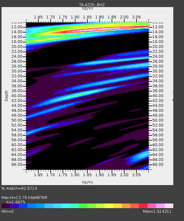
| Estimated Moho Depth: |
12.75 km |
| Estimated Crust Vp/Vs: |
1.89 |
| Assumed Crust Vp: |
5.782 km/s |
| Estimated Crust Vs: |
3.063 km/s |
| Estimated Crust Poisson's Ratio: |
0.30 |
|
| Radial Match: |
92.5714 % |
| Radial Bump: |
346 |
| Transverse Match: |
73.00091 % |
| Transverse Bump: |
400 |
| SOD ConfigId: |
21709731 |
| Insert Time: |
2020-07-08 17:55:07.862 +0000 |
| GWidth: |
2.5 |
| Max Bumps: |
400 |
| Tol: |
0.001 |
|
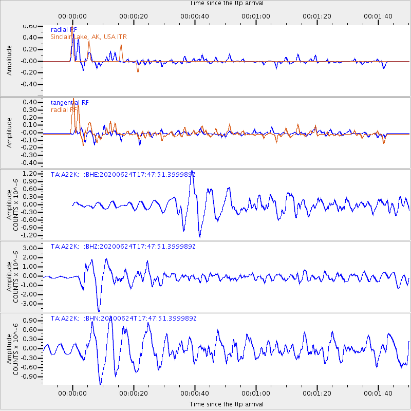
Signal To Noise
| Channel | StoN | STA | LTA |
| TA:A22K: :BHZ:20200624T17:47:51.399989Z | 6.5189767 | 6.276654E-7 | 9.6282804E-8 |
| TA:A22K: :BHN:20200624T17:47:51.399989Z | 1.4001845 | 1.6554809E-7 | 1.18233054E-7 |
| TA:A22K: :BHE:20200624T17:47:51.399989Z | 2.5445135 | 2.34046E-7 | 9.1980645E-8 |
| Arrivals |
| Ps | 2.1 SECOND |
| PpPs | 6.0 SECOND |
| PsPs/PpSs | 8.1 SECOND |


