You are here: Home > Network List > TA - USArray Transportable Network (new EarthScope stations) Stations List
> Station C26K Camden Bay, AK, USA > Earthquake Result Viewer
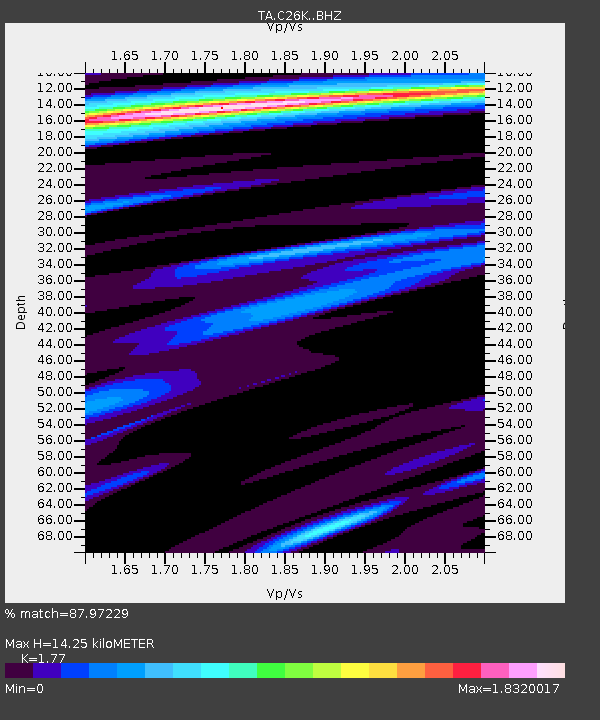
C26K Camden Bay, AK, USA - Earthquake Result Viewer
| Earthquake location: |
California-Nevada Border Region |
| Earthquake latitude/longitude: |
36.5/-118.0 |
| Earthquake time(UTC): |
2020/06/24 (176) 17:40:49 GMT |
| Earthquake Depth: |
2.9 km |
| Earthquake Magnitude: |
6.0 me |
| Earthquake Catalog/Contributor: |
NEIC PDE/ci |
|
| Network: |
TA USArray Transportable Network (new EarthScope stations) |
| Station: |
C26K Camden Bay, AK, USA |
| Lat/Lon: |
69.92 N/144.91 W |
| Elevation: |
139 m |
|
| Distance: |
36.5 deg |
| Az: |
344.761 deg |
| Baz: |
142.155 deg |
| Ray Param: |
0.07667314 |
| Estimated Moho Depth: |
14.25 km |
| Estimated Crust Vp/Vs: |
1.77 |
| Assumed Crust Vp: |
6.455 km/s |
| Estimated Crust Vs: |
3.647 km/s |
| Estimated Crust Poisson's Ratio: |
0.27 |
|
| Radial Match: |
87.97229 % |
| Radial Bump: |
400 |
| Transverse Match: |
72.833374 % |
| Transverse Bump: |
400 |
| SOD ConfigId: |
21709731 |
| Insert Time: |
2020-07-08 17:55:25.760 +0000 |
| GWidth: |
2.5 |
| Max Bumps: |
400 |
| Tol: |
0.001 |
|

Signal To Noise
| Channel | StoN | STA | LTA |
| TA:C26K: :BHZ:20200624T17:47:25.124995Z | 3.9869173 | 4.5984524E-7 | 1.15338544E-7 |
| TA:C26K: :BHN:20200624T17:47:25.124995Z | 1.4000404 | 8.5878135E-8 | 6.1339755E-8 |
| TA:C26K: :BHE:20200624T17:47:25.124995Z | 1.511764 | 1.1641336E-7 | 7.7004984E-8 |
| Arrivals |
| Ps | 1.8 SECOND |
| PpPs | 5.7 SECOND |
| PsPs/PpSs | 7.5 SECOND |


