You are here: Home > Network List > TA - USArray Transportable Network (new EarthScope stations) Stations List
> Station D23K Nanushuk River, AK USA > Earthquake Result Viewer
D23K Nanushuk River, AK USA - Earthquake Result Viewer
| Earthquake location: |
California-Nevada Border Region |
| Earthquake latitude/longitude: |
36.5/-118.0 |
| Earthquake time(UTC): |
2020/06/24 (176) 17:40:49 GMT |
| Earthquake Depth: |
2.9 km |
| Earthquake Magnitude: |
6.0 me |
| Earthquake Catalog/Contributor: |
NEIC PDE/ci |
|
| Network: |
TA USArray Transportable Network (new EarthScope stations) |
| Station: |
D23K Nanushuk River, AK USA |
| Lat/Lon: |
68.97 N/150.68 W |
| Elevation: |
406 m |
|
| Distance: |
37.2 deg |
| Az: |
341.171 deg |
| Baz: |
133.885 deg |
| Ray Param: |
0.07630552 |
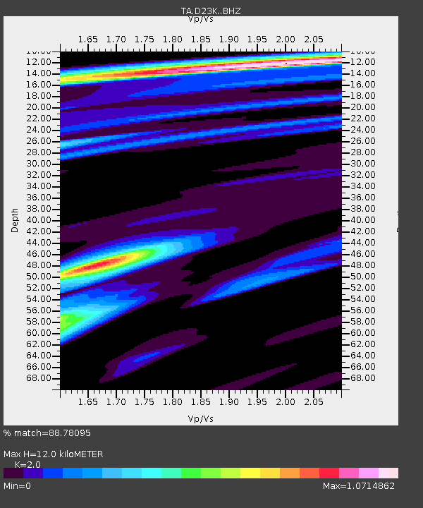
| Estimated Moho Depth: |
12.0 km |
| Estimated Crust Vp/Vs: |
2.00 |
| Assumed Crust Vp: |
6.221 km/s |
| Estimated Crust Vs: |
3.111 km/s |
| Estimated Crust Poisson's Ratio: |
0.33 |
|
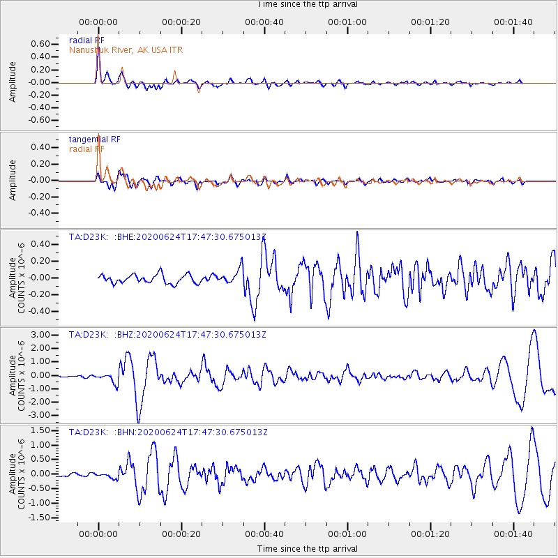
| Radial Match: |
88.78095 % |
| Radial Bump: |
400 |
| Transverse Match: |
84.032005 % |
| Transverse Bump: |
400 |
| SOD ConfigId: |
21709731 |
| Insert Time: |
2020-07-08 17:55:34.344 +0000 |
| GWidth: |
2.5 |
| Max Bumps: |
400 |
| Tol: |
0.001 |
|
Signal To Noise
| Channel | StoN | STA | LTA |
| TA:D23K: :BHZ:20200624T17:47:30.675013Z | 6.150963 | 3.6824946E-7 | 5.986858E-8 |
| TA:D23K: :BHN:20200624T17:47:30.675013Z | 1.5815238 | 9.0528665E-8 | 5.7241415E-8 |
| TA:D23K: :BHE:20200624T17:47:30.675013Z | 1.8209294 | 9.33349E-8 | 5.1256734E-8 |
| Arrivals |
| Ps | 2.0 SECOND |
| PpPs | 5.4 SECOND |
| PsPs/PpSs | 7.5 SECOND |


