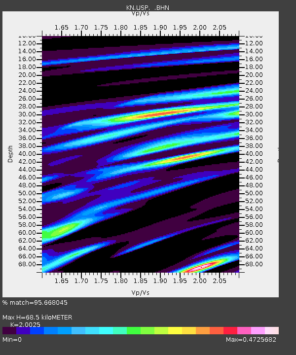
USP KN.USP - Earthquake Result Viewer

Earthquake location: Kuril Islands
Earthquake latitude/longitude: 44.5/149.1
Earthquake time(UTC): 1995/11/24 (328) 17:24:12 GMT
Earthquake Depth: 33 km
Earthquake Magnitude: 6.1 MB, 6.3 MS, 6.1 UNKNOWN, 6.6 MW
Earthquake Catalog/Contributor: WHDF/NEIC
Network: KN Kyrgyz Seismic Telemetry Network
Station: USP KN.USP
Lat/Lon: 43.27 N/74.50 E
Elevation: 740 m
Distance: 52.0 deg
Az: 296.604 deg
Baz: 61.081 deg
Ray Param: 0.067005455
Estimated Moho Depth: 68.5 km
Estimated Crust Vp/Vs: 2.00
Assumed Crust Vp: 6.306 km/s
Estimated Crust Vs: 3.149 km/s
Estimated Crust Poisson's Ratio: 0.33
Radial Match: 95.668045 %
Radial Bump: 283
Transverse Match: 84.44192 %
Transverse Bump: 400
SOD ConfigId: 6273
Insert Time: 2010-03-08 22:08:41.727 +0000
GWidth: 2.5
Max Bumps: 400
Tol: 0.001

Signal To Noise

ChannelStoNSTALTA
KN:USP: :BHN:19951124T17:32:47.700012Z9.6356861.248951E-61.2961723E-7
KN:USP: :BHE:19951124T17:32:47.700012Z17.2308241.8412345E-61.0685702E-7
KN:USP: :BHZ:19951124T17:32:47.700012Z40.520683.9373967E-69.717005E-8
Arrivals
Ps11 SECOND
PpPs31 SECOND
PsPs/PpSs43 SECOND