You are here: Home > Network List > TA - USArray Transportable Network (new EarthScope stations) Stations List
> Station F17K Baldwin Penninsula, AK, USA > Earthquake Result Viewer
F17K Baldwin Penninsula, AK, USA - Earthquake Result Viewer
| Earthquake location: |
California-Nevada Border Region |
| Earthquake latitude/longitude: |
36.5/-118.0 |
| Earthquake time(UTC): |
2020/06/24 (176) 17:40:49 GMT |
| Earthquake Depth: |
2.9 km |
| Earthquake Magnitude: |
6.0 me |
| Earthquake Catalog/Contributor: |
NEIC PDE/ci |
|
| Network: |
TA USArray Transportable Network (new EarthScope stations) |
| Station: |
F17K Baldwin Penninsula, AK, USA |
| Lat/Lon: |
66.44 N/161.25 W |
| Elevation: |
51 m |
|
| Distance: |
39.0 deg |
| Az: |
334.007 deg |
| Baz: |
118.466 deg |
| Ray Param: |
0.07530602 |
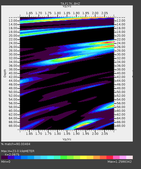
| Estimated Moho Depth: |
23.0 km |
| Estimated Crust Vp/Vs: |
2.10 |
| Assumed Crust Vp: |
6.276 km/s |
| Estimated Crust Vs: |
2.992 km/s |
| Estimated Crust Poisson's Ratio: |
0.35 |
|
| Radial Match: |
90.00484 % |
| Radial Bump: |
400 |
| Transverse Match: |
73.46769 % |
| Transverse Bump: |
400 |
| SOD ConfigId: |
21709731 |
| Insert Time: |
2020-07-08 17:56:00.612 +0000 |
| GWidth: |
2.5 |
| Max Bumps: |
400 |
| Tol: |
0.001 |
|

Signal To Noise
| Channel | StoN | STA | LTA |
| TA:F17K: :BHZ:20200624T17:47:45.524989Z | 3.7445195 | 3.4630193E-7 | 9.248234E-8 |
| TA:F17K: :BHN:20200624T17:47:45.524989Z | 1.2310468 | 1.458514E-7 | 1.18477544E-7 |
| TA:F17K: :BHE:20200624T17:47:45.524989Z | 1.4680293 | 1.866646E-7 | 1.2715319E-7 |
| Arrivals |
| Ps | 4.3 SECOND |
| PpPs | 11 SECOND |
| PsPs/PpSs | 15 SECOND |


