You are here: Home > Network List > TA - USArray Transportable Network (new EarthScope stations) Stations List
> Station F21K Alatna River, AK, USA > Earthquake Result Viewer
F21K Alatna River, AK, USA - Earthquake Result Viewer
| Earthquake location: |
California-Nevada Border Region |
| Earthquake latitude/longitude: |
36.5/-118.0 |
| Earthquake time(UTC): |
2020/06/24 (176) 17:40:49 GMT |
| Earthquake Depth: |
2.9 km |
| Earthquake Magnitude: |
6.0 me |
| Earthquake Catalog/Contributor: |
NEIC PDE/ci |
|
| Network: |
TA USArray Transportable Network (new EarthScope stations) |
| Station: |
F21K Alatna River, AK, USA |
| Lat/Lon: |
67.22 N/153.48 W |
| Elevation: |
597 m |
|
| Distance: |
36.8 deg |
| Az: |
337.832 deg |
| Baz: |
128.62 deg |
| Ray Param: |
0.07651357 |
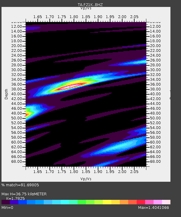
| Estimated Moho Depth: |
36.75 km |
| Estimated Crust Vp/Vs: |
1.78 |
| Assumed Crust Vp: |
6.455 km/s |
| Estimated Crust Vs: |
3.621 km/s |
| Estimated Crust Poisson's Ratio: |
0.27 |
|
| Radial Match: |
91.69805 % |
| Radial Bump: |
303 |
| Transverse Match: |
68.40482 % |
| Transverse Bump: |
400 |
| SOD ConfigId: |
21709731 |
| Insert Time: |
2020-07-08 17:56:06.082 +0000 |
| GWidth: |
2.5 |
| Max Bumps: |
400 |
| Tol: |
0.001 |
|
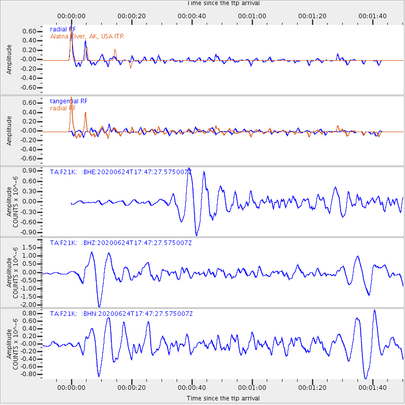
Signal To Noise
| Channel | StoN | STA | LTA |
| TA:F21K: :BHZ:20200624T17:47:27.575007Z | 4.90981 | 2.6113761E-7 | 5.3186902E-8 |
| TA:F21K: :BHN:20200624T17:47:27.575007Z | 2.680874 | 1.04972464E-7 | 3.915606E-8 |
| TA:F21K: :BHE:20200624T17:47:27.575007Z | 2.825447 | 1.0342654E-7 | 3.660537E-8 |
| Arrivals |
| Ps | 4.8 SECOND |
| PpPs | 15 SECOND |
| PsPs/PpSs | 20 SECOND |


