You are here: Home > Network List > TA - USArray Transportable Network (new EarthScope stations) Stations List
> Station G21K Allakaket, AK, USA > Earthquake Result Viewer
G21K Allakaket, AK, USA - Earthquake Result Viewer
| Earthquake location: |
California-Nevada Border Region |
| Earthquake latitude/longitude: |
36.5/-118.0 |
| Earthquake time(UTC): |
2020/06/24 (176) 17:40:49 GMT |
| Earthquake Depth: |
2.9 km |
| Earthquake Magnitude: |
6.0 me |
| Earthquake Catalog/Contributor: |
NEIC PDE/ci |
|
| Network: |
TA USArray Transportable Network (new EarthScope stations) |
| Station: |
G21K Allakaket, AK, USA |
| Lat/Lon: |
66.52 N/153.51 W |
| Elevation: |
446 m |
|
| Distance: |
36.4 deg |
| Az: |
336.888 deg |
| Baz: |
127.841 deg |
| Ray Param: |
0.07675127 |
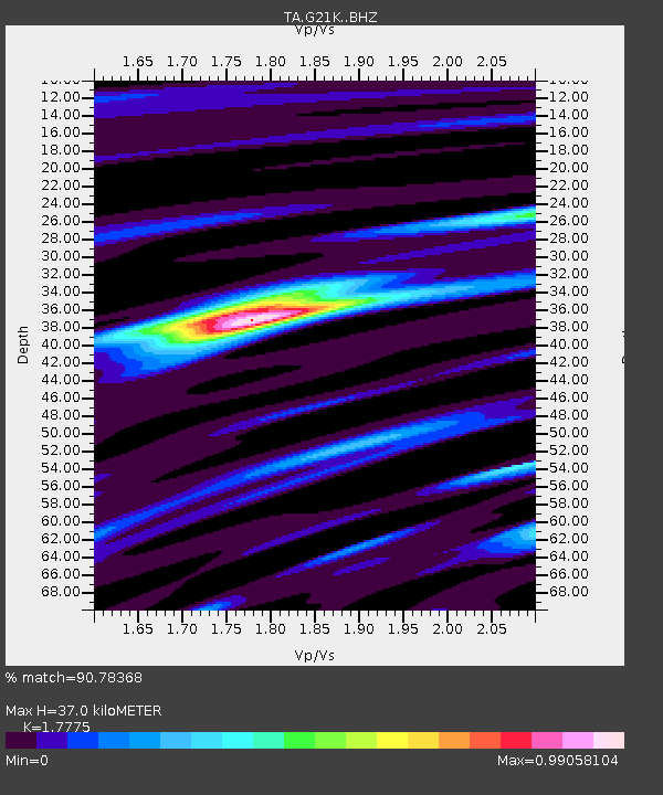
| Estimated Moho Depth: |
37.0 km |
| Estimated Crust Vp/Vs: |
1.78 |
| Assumed Crust Vp: |
6.455 km/s |
| Estimated Crust Vs: |
3.632 km/s |
| Estimated Crust Poisson's Ratio: |
0.27 |
|
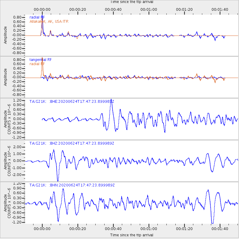
| Radial Match: |
90.78368 % |
| Radial Bump: |
308 |
| Transverse Match: |
71.085846 % |
| Transverse Bump: |
400 |
| SOD ConfigId: |
21709731 |
| Insert Time: |
2020-07-08 17:56:24.947 +0000 |
| GWidth: |
2.5 |
| Max Bumps: |
400 |
| Tol: |
0.001 |
|
Signal To Noise
| Channel | StoN | STA | LTA |
| TA:G21K: :BHZ:20200624T17:47:23.899989Z | 7.2486353 | 4.673091E-7 | 6.446856E-8 |
| TA:G21K: :BHN:20200624T17:47:23.899989Z | 3.0753527 | 1.7337729E-7 | 5.637639E-8 |
| TA:G21K: :BHE:20200624T17:47:23.899989Z | 2.937581 | 1.9670217E-7 | 6.696059E-8 |
| Arrivals |
| Ps | 4.8 SECOND |
| PpPs | 15 SECOND |
| PsPs/PpSs | 20 SECOND |


