You are here: Home > Network List > TA - USArray Transportable Network (new EarthScope stations) Stations List
> Station H31M Peel River, Yukon, CAN > Earthquake Result Viewer
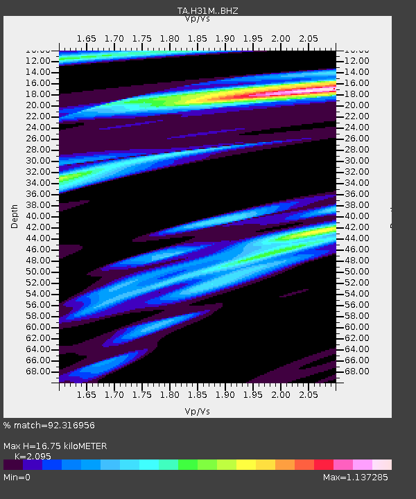
H31M Peel River, Yukon, CAN - Earthquake Result Viewer
| Earthquake location: |
California-Nevada Border Region |
| Earthquake latitude/longitude: |
36.5/-118.0 |
| Earthquake time(UTC): |
2020/06/24 (176) 17:40:49 GMT |
| Earthquake Depth: |
2.9 km |
| Earthquake Magnitude: |
6.0 me |
| Earthquake Catalog/Contributor: |
NEIC PDE/ci |
|
| Network: |
TA USArray Transportable Network (new EarthScope stations) |
| Station: |
H31M Peel River, Yukon, CAN |
| Lat/Lon: |
65.81 N/134.34 W |
| Elevation: |
642 m |
|
| Distance: |
30.9 deg |
| Az: |
346.937 deg |
| Baz: |
153.758 deg |
| Ray Param: |
0.07927393 |
| Estimated Moho Depth: |
16.75 km |
| Estimated Crust Vp/Vs: |
2.10 |
| Assumed Crust Vp: |
6.419 km/s |
| Estimated Crust Vs: |
3.064 km/s |
| Estimated Crust Poisson's Ratio: |
0.35 |
|
| Radial Match: |
92.316956 % |
| Radial Bump: |
400 |
| Transverse Match: |
80.63319 % |
| Transverse Bump: |
400 |
| SOD ConfigId: |
21709731 |
| Insert Time: |
2020-07-08 17:56:45.574 +0000 |
| GWidth: |
2.5 |
| Max Bumps: |
400 |
| Tol: |
0.001 |
|

Signal To Noise
| Channel | StoN | STA | LTA |
| TA:H31M: :BHZ:20200624T17:46:36.475001Z | 8.432498 | 3.907767E-7 | 4.6341746E-8 |
| TA:H31M: :BHN:20200624T17:46:36.475001Z | 3.833137 | 2.53466E-7 | 6.6124954E-8 |
| TA:H31M: :BHE:20200624T17:46:36.475001Z | 2.2532527 | 9.3968346E-8 | 4.170342E-8 |
| Arrivals |
| Ps | 3.1 SECOND |
| PpPs | 7.5 SECOND |
| PsPs/PpSs | 11 SECOND |


