You are here: Home > Network List > KN - Kyrgyz Seismic Telemetry Network Stations List
> Station USP KN.USP > Earthquake Result Viewer
USP KN.USP - Earthquake Result Viewer
| Earthquake location: |
Northern Molucca Sea |
| Earthquake latitude/longitude: |
2.6/127.7 |
| Earthquake time(UTC): |
1995/07/26 (207) 23:42:02 GMT |
| Earthquake Depth: |
66 km |
| Earthquake Magnitude: |
5.9 MB, 6.4 UNKNOWN, 6.4 MW |
| Earthquake Catalog/Contributor: |
WHDF/NEIC |
|
| Network: |
KN Kyrgyz Seismic Telemetry Network |
| Station: |
USP KN.USP |
| Lat/Lon: |
43.27 N/74.50 E |
| Elevation: |
740 m |
|
| Distance: |
62.1 deg |
| Az: |
318.577 deg |
| Baz: |
115.197 deg |
| Ray Param: |
0.06026816 |
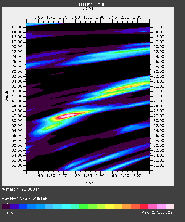
| Estimated Moho Depth: |
47.75 km |
| Estimated Crust Vp/Vs: |
1.77 |
| Assumed Crust Vp: |
6.306 km/s |
| Estimated Crust Vs: |
3.568 km/s |
| Estimated Crust Poisson's Ratio: |
0.26 |
|
| Radial Match: |
96.38044 % |
| Radial Bump: |
378 |
| Transverse Match: |
88.412224 % |
| Transverse Bump: |
400 |
| SOD ConfigId: |
6273 |
| Insert Time: |
2010-03-08 22:09:27.165 +0000 |
| GWidth: |
2.5 |
| Max Bumps: |
400 |
| Tol: |
0.001 |
|

Signal To Noise
| Channel | StoN | STA | LTA |
| KN:USP: :BHN:19950726T23:51:46.000024Z | 3.6625092 | 1.6772653E-7 | 4.5795524E-8 |
| KN:USP: :BHE:19950726T23:51:46.000024Z | 6.50258 | 3.6909594E-7 | 5.676146E-8 |
| KN:USP: :BHZ:19950726T23:51:46.000024Z | 25.175097 | 1.0330732E-6 | 4.103552E-8 |
| Arrivals |
| Ps | 6.1 SECOND |
| PpPs | 20 SECOND |
| PsPs/PpSs | 26 SECOND |


