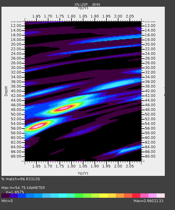
USP KN.USP - Earthquake Result Viewer

Earthquake location: Southern Sumatra, Indonesia
Earthquake latitude/longitude: -2.1/101.4
Earthquake time(UTC): 1995/10/06 (279) 18:09:45 GMT
Earthquake Depth: 33 km
Earthquake Magnitude: 5.8 MB, 6.9 MS, 6.8 UNKNOWN, 6.8 MW
Earthquake Catalog/Contributor: WHDF/NEIC
Network: KN Kyrgyz Seismic Telemetry Network
Station: USP KN.USP
Lat/Lon: 43.27 N/74.50 E
Elevation: 740 m
Distance: 51.2 deg
Az: 334.907 deg
Baz: 144.536 deg
Ray Param: 0.06748403
Estimated Moho Depth: 54.75 km
Estimated Crust Vp/Vs: 1.66
Assumed Crust Vp: 6.306 km/s
Estimated Crust Vs: 3.805 km/s
Estimated Crust Poisson's Ratio: 0.21
Radial Match: 96.933105 %
Radial Bump: 317
Transverse Match: 81.18169 %
Transverse Bump: 400
SOD ConfigId: 6273
Insert Time: 2010-03-08 22:09:43.682 +0000
GWidth: 2.5
Max Bumps: 400
Tol: 0.001

Signal To Noise

ChannelStoNSTALTA
KN:USP: :BHN:19951006T18:18:15.650Z3.11816052.069694E-76.637548E-8
KN:USP: :BHE:19951006T18:18:15.650Z2.63291811.673119E-76.354618E-8
KN:USP: :BHZ:19951006T18:18:15.650Z9.872924.972007E-75.0360043E-8
Arrivals
Ps6.1 SECOND
PpPs22 SECOND
PsPs/PpSs28 SECOND